Students of AKTU’s B.Tech., take note! Looking for a thorough study guide to assist you in getting ready for the Surveying and Geomatics exam? Check out our resource, which includes notes on the key questions and answers for Unit 3 MODERN FIELD SURVEY SYSTEMS.
Dudes 🤔.. You want more useful details regarding this subject. Please keep in mind this as well.

Important Questions For Surveying And Geomatics:
*Unit-01     *Unit-02
*Unit-03    *Unit-04
*Unit-05    *Short-Q/Ans
*Question-Paper with solution 21-22
Q1. Define the EDM. Discuss briefly the method of measuring distance between two points.
Ans. A. EDM:
- 1. An electronic distance measurement gadget uses electromagnetic waves to electrically measure the distance between two places.
- 2. Electronic distance measuring (EDM) uses the phase shifts that take place as electromagnetic energy waves go from one end of the line to the other end to calculate the distance between two places.
B. Measuring Method : Following are three methods of measuring distance between two points :
1. DDM or Direct Distance Measurement : This is mainly done by chaining or taping.
2. ODM or Optical Distance Measurement : Tacheometry, the horizontal subtense technique, or telemetry are used to take this measurement. These are accomplished via optical wedge attachments.
3. EDM or Electromagnetic Distance Measµrement : In rough terrains, the direct distance measurement method cannot be used. This strategy should not be used when the landscape is unevenly vast or there are substantial impediments.
Q2. Describe the principle of differential GPS.
Ans. A. GPS:
- 1. The GPS is a space-based, all-weather radio navigation system that can swiftly, precisely, and affordably determine an object’s time, position, and velocity anywhere in the world at any given moment.
- 2. The present GPS system is based on precise timekeeping and ephemeris data on each satellite’s current location.
- 3. It generates distances in order to triangulate positions anywhere on Earth using satellite signals, precise time, and complex algorithms.
- 4. Users with the appropriate receiving equipment can access accurate, continuous, global, three-dimensional position and velocity information from the system.
- 5. The global positioning system is comprised of three segments :
- i. Satellite constellation called space segment.
- ii.Ground control/monitoring network called operational control segment.
- iii. User receiving equipment called user equipment segment.
B. Types : Following are two types of GPS system :
1. Differential GPS :
- i. It is a system in which differential corrections differences between observed and computed coordinates or ranges are sent to users at a certain known location known as the reference station to increase the accuracy of the user’s receiver position. In truth, DGPS is a technique for enhancing GPS accuracy.
- ii. Real-time coordinate determination for moving platforms or rovers is done using DGPS, which is primarily a navigation technology.
Principle of DGPS :
- i. It is predicated on the idea that bias errors in position are common to all sites within a specific geographic area (say within 100 km).
- ii. Unfortunately, because the satellite faults are constantly changing, a user cannot simply identify the error once and apply it to correct all measurements taken for the rest of the day.
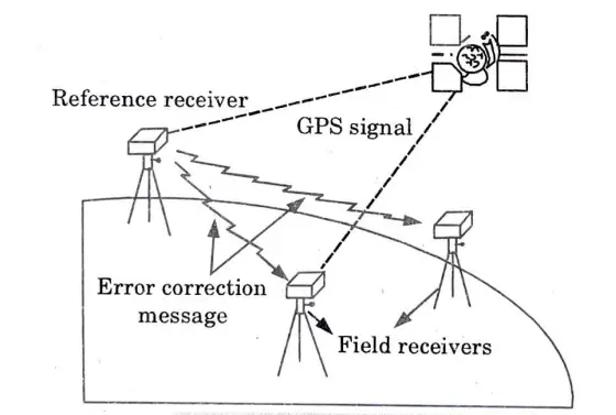
- iii. In order to complete the task, a user needs two receivers operating concurrently. The second receiver, which is out performing positioning work, can apply these corrections to its measurements either as it is making them or at a later time because the reference receiver remains stationary and continuously monitors the errors before transmitting or recording corrections for those errors.
- iv. As a result, the user is able to fine-tune the accuracy of a wandering receiver, or for an entire fleet of roving receivers as shown in Fig.
Advantages of DGPS :
- i. It improves accuracy.
- ii. DGPS works by canceling out most of the natural and man-made errors_ that keep into normal GPS measurements.
2. Kinematic GPS:
- i. Real Time Kinematic is the name given to it (RTK). When GPS, GLONASS, and/or Galileo cannot be used together, RTKsatellite navigation is a technique used to increase the accuracy of position data received from satellite-based positioning systems.
- ii. It relies on a single reference station to give real-time corrections, enabling precision of up to a centimetre, and measures the phase of the signal’s carrier wave rather than the signal’s information content.
- iii. In relation to GPS CPGPS, often known as carrier phase enhancement, is the name of this system. It has numerous uses in both hydrographic and terrestrial surveys.
- iv. The operational reliability and accuracy of a reference station network are dependent on the density and capabilities of the network of reference stations, and this is where the Virtual Reference Station (VRS) technique comes in.
Q3. Explain the principle which helps GPS to determine the position of place.
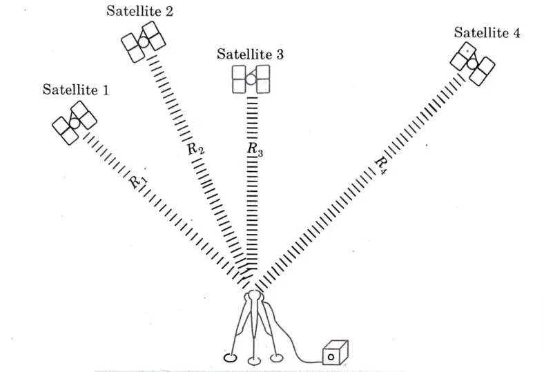
Ans. Principle of Global Positioning System :
- 1. GPS receivers on the ground use the GPS satellites as reference points to recalculate their positions.
- 2. As illustrated in Fig., the basic navigational theory is based on measurements of the pseudoranges between the user and four satellites.
- 3. The four distances between the satellites and the receiver are computed in order to produce precise position, direction, and speed. The satellites are orbiting at a height of 20200 km above the Earth.
- 4. The GPS methodology eliminates the numerous drawbacks of terrestrial surveying methods, such as the need for survey stations to be visible to each other, reliance on the weather, challenges with observation, etc.
.
- 5. The use of GPS technology includes geodetic control and survey control for photogrammetric control surveys and mapping, offshore drilling location determination, pipeline and power line location determination, civilian ship and aircraft navigation, crustal movement studies, geophysical positioning, mineral exploration and mining, precise geoid determination, gravity anomaly estimation, and other uses.
Q4. Discuss about the following terms :
A. GLONASS.
B. GALILEO.
Ans. A. GLONASS :
- 1. It is a satellite navigation system that offers both military and civilian users real-time position and velocity determination.
- 2. The satellites are in a middle circular orbit, 19,100 km above the earth, with a period of 11 hours and 15 minutes and an inclination of 64.8 degrees.
- 3. Due to its orbit, GLONASS is particularly useful in high latitudes (north or south), where receiving a GPS signal might be challenging.
- 4. The constellation has eight evenly spaced satellites on each of its three orbital planes.
- 5. While 18 satellites are required to cover all of Russia, a fully operating constellation with worldwide coverage comprises of 24 satellites.
- 6. The receiver needs to be within range of at least four satellites in order to obtain a location fix.
B. GALILEO:
- 1. Galileo’s primary goal is to offer a very accurate positioning system.
- 2. It is designed to offer higher positioning accuracy at high altitudes than GPS and GLONASS systems, measuring horizontal and vertical positions with a precision of 1 m.
- 3. Galileo will eventually consist of 30 satellites in Medium Earth Orbit (MEO). In relation to the equatorial plane, the constellation is 56° inclined. The Galileo orbit inclination was chosen to guarantee successful operation at polar latitudes, particularly in northern Europe.
- 4. The users will receive a signal from this system letting them know that their predicament has been noticed and assistance is on the way.
Q5. How has GPS revolutionized our life ? Explain.
Ans. Application : Following are the various applications of GPS :
1. Navigation:
- i. The two most obvious uses of GPS are probably marine and aviation navigation. Both military personnel and civilians desire the most accurate knowledge about their spatial positions.
- ii. The regional uses of GPS include automation of various kinds, monitoring of structural integrity, and transportation management.
- iii. GPS can help in berthing and docking of large vessels when used locally.
2. Surveying:
- i. A new age in surveying has been ushered in by the integration of real-time positioning, mobile data connectivity, and on-board data processing and applications software.
- ii. GPS technology make it possible to collect data on specific border, cross section, and profile sites. Contours can then be easily produced using the gathered information.
- iii. Local GPS applications include local property and site surveys, topographic mapping, and the use of GPS kinematic surveying to pinpoint the location of the photocentre during aerial mapping flights.
3. Mapping:
- i. The provision of ground truthing, or the orientation of aerial photogrammetry, was a significant early application of GPS.
- ii. Index markings are frequently surveyed on the ground to provide places for these pictures to be scaled and oriented in relation to. These references can be surveyed using GPS.
- iii. It is now quite simple to create a road map or any other type of feature map by simply recording a sequence of positions while a receiver is moved across the region to be mapped.
4. Remote Sensing:
- i. Additionally, GPS tracking can be incorporated with remote sensing techniques including photogrammetry, aerial scanning, magnetometry, and video technology.
5. Military and Space:
- i. GPS was designed and built with military applications in mind. There has been considerable use of GPS in spacecraft.
- ii. GPS has been used on multiple shuttle missions and has proved effective in delivering better orbital placement in a lot less time than was previously achievable.
6. Agriculture:
- i. In developed nations, GPS is ushering in a new era of precision farming.
- ii. A farmer can create a fertiliser demand map by examining the soil quality in each area of his farm. The GPS system computer has digitized and saved this map.
- iii. To calculate the precise amount of fertiliser or pesticide to be administered at each spot as the chemical spreader passes through the farmer’s fields, its GPS-measured position is compared with the demand map that has been previously saved.
7. GPS in Land Use:
- i. A region’s land use and land cover patterns are a result of how people have used social and economic elements over time and space. Because of intense agricultural and demographic demand, land is becoming a precious resource. In order to choose, plan, and implement land use schemes that will satisfy the growing demand for fundamental human requirements and welfare, knowledge on land use/land cover and possibilities for their best use is crucial.
- ii. This data also helps in tracking the dynamics of land usage as a result of shifting population demands.
- iii. Earth sensing satellite data has grown increasingly important in recent years for mapping the earth’s features and infrastructures, managing natural resources, and researching environmental change.
Q6. Explain the functions of GIS.
Ans. Function : Following are the various functions of GIS :
- 1. Buffering.
- 2. Reclassification.
- 3. Overlay analysis.
- 4. Proximity analysis.
- 5. Filtering.
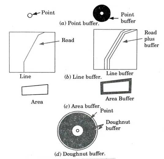
1. Buffering :
- i. It is the creation of a zone of interest around an entity.
- ii. It is possible both in vector and raster data format.
- iii. In vectors case, the result is a new set of objects.
- iv. Buffers are very useful for analyzing landscapes, highway alignments water supply networks and drainage studies.
- v. Buffering is very simple but involves complex computational operation.
- vi. If a point is buffered, a circular zone is created. Buffering lines and areas creates new areas.
- vii. The simplest operation is to simply draw a circle with the necessary radius around each point to create buffer zones around point features.
- viii. In order to accomplish this, some GIS place a circle with the necessary radius at one end of the line or area boundary that needs to be buffered. The circle is then moved down the segment’s length.
- ix. In some cases, a buffer may need to be surrounded by another buffer. This is called doughnut buffer.

Surveying And Geomatics Quantum, Syllabus, Important Questions
| Label | Link |
|---|---|
| Subject Syllabus | Syllabus |
| Short Questions | Short-question |
| Important Unit-1 | Unit-1 |
| Important Unit-2 | Unit-2 |
| Important Unit-3 | Unit-3 |
| Important Unit-4 | Unit-4 |
| Important Unit-5 | Unit-5 |
| Question paper – 2021-22 | 2021-22 |
Surveying And Geomatics Quantum PDF: | AKTU Quantum PDF:
| Quantum Series | Links |
| Quantum -2022-23 | 2022-23 |
AKTU Important Links | Btech Syllabus
| Link Name | Links |
|---|---|
| Btech AKTU Circulars | Links |
| Btech AKTU Syllabus | Links |
| Btech AKTU Student Dashboard | Student Dashboard |
| AKTU RESULT (One VIew) | Student Result |