Take note, B.Tech. students at AKTU! Are you looking for a comprehensive study guide to help you prepare for the Surveying and Geomatics exam? Visit our website to get notes on the important inquiries and solutions for Unit 05 REMOTE SENSING.
Dudes 🤔.. You want more useful details regarding this subject. Please keep in mind this as well.

Important Questions For Surveying And Geomatics:
*Unit-01     *Unit-02
*Unit-03    *Unit-04
*Unit-05    *Short-Q/Ans
*Question-Paper with solution 21-22
Q1. What do you understand by the term “Remote sensing”?
Ans. A. Remote Sensing :
- 1. Remote sensing is the practise of using a camera to take photos of any place without physically touching it.
- 2. Aerial photography is the first remote sensing method. These images were captured from the air using aeroplanes.
- 3. Aerial photography has several uses, including disaster management for floods, landslides, and forest fires, military applications for geological surveys, urban planning, and the extraction of minerals and oil, among others.
B. Advantages of Remote Sensing: Following arse the advantages of remote sensing :
- 1. It provides a synoptic overview of the surface of the earth.
- 2. The remote sensing technology produces multi-spectral, repetitively covered data.
- 3. It may gather photographs and describe the disaster’s severity and aerial expansion.
- 4. This method can assist in obtaining the information in a brief amount of time.
- 5. Its data can be used across multiple disciplines, such as disaster management, geological surveys, urban planning, and land use planning.
C. Limitations of Remote Sensing Techniques :
- 1. There is no way to match an aerial shot with the ground in satellite images or in aerial photos.
- 2. It requires a qualified individual to gather, analyse, and map the data.
- 3. It also entails data processing to extract data for direct input into a geographic information system (GIS).
Q2. What are the characteristics of ideal remote sensing systems ? How do the real remote sensing systems differ from the ideal requirements?
Ans. A. Characteristics : Following are the main characteristics of ideal remote sensing system :
- 1. It has uniform energy source.
- 2. It contains non-interfering atmosphere.
- 3. It uses distinct and unique spectral response patterns for every feature.
- 4. It includes super-sensor.
- 5. It has real time data acquisition.
- 6. It includes multiple users.
B. Difference : Following are the difference between ideal and real remote sensing system :
| S. No. | Aspect | Ideal Remote Sensing System | Real Remote Sensing System |
| 1. | Energy source | It has uniform energy source, irrespective of time and place. | Energy changes in unpredictable ways depending on the moment, the environment, and the item. |
| 2. | Atmosphere | Its atmosphere is non-interfering and will not absorb or scatter electromagnetic energy. | It varies according to latitude, season, time of day, local weather etc. |
| 3. | Spectral response | Everywhere on the surface of the globe, each object would have a distinct and well-known spectral response. | In practical, these may change and cannot always be distinguished. |
| 4. | Sensing system | a very sensitive sensor that can detect all relevant wavelengths. | No present sensing technology can function at any relevant wavelength. |
Q3. Explain with the help of a neat sketch an idealized remote sensing system.
Ans. The ideal remote sensing system comprises of the following :
1. A Uniform EM Energy Source : No matter the time or location, it should deliver energy of all wavelengths at a consistent intensity at a high level of output.
2. A Non-interfering Atmosphere : To prevent energy from being altered in the atmosphere, EM energy must go to or from the target without experiencing any loss during transmission via the atmosphere. It should ideally hold regardless of wavelength, time, location, and sensing height.
3. A Series of Unique Energy (Matter Interactions at the Earth’s Surface) : These interactions produce reflected and emitted signals that are selective in terms of wavelength, invariant, and particular to each and every type and sub-type of interesting features on the earth’s surface.
4. A Super Sensor :
i. The sensor, whether it be airborne or spaceborne, must be extremely sensitive to all wavelengths and produce spatially precise data on the absolute brightness (radiance) of the target as a function of wavelength.
ii. The super sensor would be easy to use, dependable, almost power- or space-free, accurate, and cost-effective to operate.
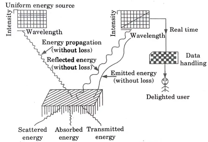
5. A Real Time Data Handling System : The data recorder captures and processes the return signal from the target that reaches a sensor in real time (almost instantly). After that, the data is transformed into a form that can be interpreted.
6. Multiple Data Users :
i. These experts would possess in-depth knowledge of both their respective fields and the methods used to collect and analyze remote sensing data.
ii. For different users, the same collection of data would take on distinct forms of information.
7. Linear Sensor: A sensor which responds linearly to EM energy of all wavelength.
Q4. Write a short note on spectral signature.
Ans. Spectral Signature:
- 1. A material’s reflectance or emittance varies depending on the wavelength.
- 2. Stars’ spectral signatures reveal the make-up of their stellar atmosphere.
- 3. The incidental EM wavelength and the material’s interaction with that region of the electromagnetic spectrum determine an object’s spectral signature.
- 4. Different devices, such as task-specific spectrometers, can be used to make the measurements, but the most popular technique is to separate the red, green, blue, and near-infrared portions of the electromagnetic spectrum as they are captured by digital cameras.
- 5. In order to apply a correction to digital images obtained from airborne or satellite data, calibrating spectral fingerprints are gathered under particular lighting conditions.
Q5. What are the temporal images? Why are used in remote sensing? Explain with a suitable example. Which cannot be carried out without the use of temporal images.
Ans. Temporal Image: Temporal refers to a matter of time. So, temporal images are snapshots of the scene taken at a certain moment in time.
Uses of Temporal Images in Remote Sensing:
- 1. Information from remote sensing data is crucial for monitoring a variety of applications, including image fusion, change detection, and land cover classification.
- 2. One important method for learning about the resources and environment of the earth is remote sensing. As we all know, temporal pictures are snapshots of a scene taken at a specific moment in time. The real apps will determine how long it takes to take one image. The image should be taken during the off-growing season if the application is to create a soil map.
- 3. Similar to that, off-season imaging is also used to map agricultural residue for conservation methods. On the other hand, if crop monitoring is the goal, the remote sensing data should be collected during the growth season. Therefore, temporal images are typically utilised in remote sensing to identify change.
Example:
- 1. For crop monitoring the remote sensing imagery should be obtained from the growing season. It is helpful for proper yield estimation and management if the temporal relationship between image and yield could be identified. Since the variation of crop spectral reflectance during the · growing season can be used to relate to yield, it could help growers to estimate yield during the growing season.
- 2. Furthermore in-seasonal image data acquisition might need to occur many times to better understand the growth pattern and in-field variability.
Q6. Explain the various applications of remote sensing.
Ans. Following are the applications of remote sensing :
1. Agriculture :
- i. Early season estimation of total cropped area.
- ii. Monitoring crop condition using crop growth profile.
- iii Identification of crops and their coverage estimation in multi-cropped regions.
- iv. Crop yield modeling.
- v. Cropping system/crop rotation studies.
- vi. Command area management.
- vii. Detection of moisture stress in crops and quantification of its effect on crop yield.
2. Forestry :
- i. Improved forest type mapping.
- ii. Monitoring large scale deforestation, forest fire.
- iii. Monitoring urban forestry.
- iv. Forest stock mapping.
- v. Wild life habitat assessment.
3. Land Use and Soils:
- i. Mapping land use/cover (level III) at 1 : 25000 scale or better.
- ii. Change 0 detection.
- iii. Identification of degraded lands/erosion prone areas.
- iv. Soil categorization.
4. Geology:
- i. Lithological and structural mapping .
- ii. Geo morphological mapping.
- iii. Ground water exploration.
- iv. Drainage analysis.
- v. Mineral exploration.
- vi. Coal fire mapping.
- vii. Oil field detection.
5. Urban Land use :
- i. Urban land use level IV mapping.
- ii. Updating of urban transport network.
- iii. Identification of unauthorized structures.
6. Water Resources :
- i. Monitoring surface water bodies frequently and estimation of their spatial extent.
- ii. Snow-cloud discrimination leading to better delineation of snow area.
7. Coastal Environment :
- i. More detailed inventory of coastal land use on 1:25000 scale.
- ii. Discrimination of coastal vegetation types.
- iii. Monitoring sediment dynamics.
8. Ocean Resources :
- i. Wealth of oceans/ explorations/ productivity.
- ii. Potential fishing zone.
- iii. Coral reef mapping.
9. Environment :
- i. Impact assessment on vegetation, water bodies.
- ii. Loss of biological diversity / biosphere reserves / ecological hot spot areas / wet land environment.
10. Natural Resources Based Applications :
- i. Management of wild and scenic rivers, recreation resources, flood plains, wet lands, agricultural lands, aquifers, forest, wild life etc.
- ii. Environmental Impact Analysis (EIA).
- iii. View shed analysis.
- iv. Hazardous o.r toxic facility siting.
- v. Ground water modeling and contamination tracking.
- vi. Wild life analysis, migration routes planning.
11. Disasters :
- i. Mapping flood inundated area, damage assessment.
- ii. Disaster warning mitigation.
Surveying And Geomatics Quantum, Syllabus, Important Questions
| Label | Link |
|---|---|
| Subject Syllabus | Syllabus |
| Short Questions | Short-question |
| Important Unit-1 | Unit-1 |
| Important Unit-2 | Unit-2 |
| Important Unit-3 | Unit-3 |
| Important Unit-4 | Unit-4 |
| Important Unit-5 | Unit-5 |
| Question paper – 2021-22 | 2021-22 |
Surveying And Geomatics Quantum PDF: | AKTU Quantum PDF:
| Quantum Series | Links |
| Quantum -2022-23 | 2022-23 |
AKTU Important Links | Btech Syllabus
| Link Name | Links |
|---|---|
| Btech AKTU Circulars | Links |
| Btech AKTU Syllabus | Links |
| Btech AKTU Student Dashboard | Student Dashboard |
| AKTU RESULT (One VIew) | Student Result |