Do you need to brush up on your surveying and geomatics expertise quickly and easily? See our Quantum PDF notes, which are filled with succinct questions and answers to aid in your test preparation for the AKTU B.Tech. Our guide includes everything you need to succeed, whether you’re searching for a short refresher or a thorough study assistance.
Dudes 🤔.. You want more useful details regarding this subject. Please keep in mind this as well.

Important Questions For Surveying And Geomatics:
*Unit-01     *Unit-02
*Unit-03    *Unit-04
*Unit-05    *Short-Q/Ans
*Question-Paper with solution 21-22
Unit 01 Introduction to Surveying Short Questions with Answer
Q1. What are the assumptions made in plain survey?
Ans. Following are the main assumptions used in plain survey :
- i. The plumb line at one place is parallel to the plumb line at any other point because a level line is regarded as a straight line.
- ii. The angle formed by the intersection of two such lines is a plane angle, not a spherical angle.
- iii. Any two points meridians pass through parallel lines.
Q2. What are the basic principles of surveying ?
Ans. Following are the two basic principles of surveying :
- i. To work form whole to part.
- ii. To locate a point by at least two measurement.
Q3. What are the basic sources of error in survey? Give detail.
Ans. Following are the different sources of error in survey:
i. Instrument errors. ii. Personal errors.
iii. Natural errors.
Q4. What are the different types of errors in surveying ?
Ans. Following are the errors occurring in surveying :
i. Mistake errors. ii. Systematic errors.
iii. Accidental errors.
Q5. Define the following terms :
Level line, mean sea level, datum, bench mark.
Ans. i. Level Line: This line is on a flat surface. To have a plumb line at every location is normal.
ii. Mean Sea Level: All elevations in India are tied to the mean sea level, which is assumed to be the average elevation of the sea water at Mumbai Port.
iii. Datum: When measuring or referring to the levels of points, it is a level surface.
iv. Bench Marks: It is a known elevational fixed reference point.
Q6. Enlist various methods for classification of survey based on different criteria.
Ans. Following are the different criteria for classification of survey :
i. Accuracy desired. ii. Purpose of survey.
iii. Place of survey. iv. Instrument used.
Q7. What do you mean by working from whole to part?
Ans. i. It means that a traverse should be laid and accurately surveyed along the perimeter of the region to be surveyed.
ii. The area should then be divided into smaller traverse-sized sections, with each section being surveyed separately, and so on.
iii. This way the error in the survey work will be localized.
Q8. Give the broad classification of surveying?
Ans. Following are the classification of surveying :
i. Geodetic surveying. ii. Plane surveying.
Q9. Describe the ranging.
Ans. To enable accurate linear measurement of a survey line, ranging involves building intermediate stations on the survey line. There are two ways to range:
i. Direct ranging. ii. Indirect ranging.
Q10. How many ranging rods are required to range a line ?
Ans. For direct and indirect ranging, respectively, a minimum of three and four ranging rods are needed.
Q11. Define local attraction. How will you detect local attraction at a station ?
Ans. Local Attraction: Local attraction is any effect on the magnetic needle brought on by the presence of magnetic objects nearby, such as iron pipes, steel constructions, iron lamps, posts, railroads, cables, chain arrows, etc., which prevent the needle from pointing in the direction of magnetic north.
Detection: When the angle between the rear bearing and the forward bearing is less than 180 degrees, the station in question is impacted by a nearby attraction.
Q12. What is declination and its variations ?
Ans. Declination: Magnetic declination is the measurement of the horizontal angle between true north and magnetic north at the moment of observation.
True bearing = Magnetic bearing ± Magnetic declination (E/W)
Variations: Anywhere it occurs, the declination fluctuates with time. These variations fall under the following categories:
i. Secular variation. ii. Annual variation.
iii. Diurnal variation. iv. Irregular variation.
Q13. Write relationship between level line and horizontal line.
Ans. Horizontal line is a line in the horizontal plane and it is straight line tangential to the level line.
Q14. The magnetic bearing of a line as observed is 269°. If the local attraction at this point is known to be 5° E and the declination is 15° W. What is the true bearing of the line ?
Ans. True bearing of line = Observed bearing + East local attraction -West declination
= 269° + 5° – 15° = 259°
Q15. What is the necessity of providing tallies in a chain ?
Ans. Tallies in a chain help remember the distances to things on the line and assure measurement accuracy.
Q16. What do you mean by positive RL and negative RL ?
Ans. Positive RL is when the sighted point is above the reference point, while negative RL is when the sighted point is below the reference point.
Q17. How will you distinguish between a valley line and ridge line?·
Ans.
| S. No. | Ridge Line | Valley Line |
| i. | The higher elevation contours for ridge lines are located inside the loop or band. | Higher elevation contours outside the loop indicate a valley line. |
| ii. | Ridge lines indicate mountains, steep hills, etc. | Valley lines indicate streams or rivers. |
Q18. Enlist various causes of errors in levelling.
Ans. Following are the causes of errors in levelling :
- i. Errors due to sluggish bubble.
- ii. Errors due to faulty focusing tube.
- iii. Errors due to earth curvature and atmospheric refraction.
- iv. Error due to temperature and wind vibration.
- v. Error due to mistake in reading and recording.
- vi. Error in sighting.
Q19. What is levelling and why it is important in survey work?
Ans. Levelling : Finding the elevation difference between two sites in relation to one another is the process (on, above or below the earth surface).
Importance : Leveling is required for a number of tasks, including calculating the depth of cutting and filling, laying out the slopes for roads, pipelines, sewers, and other infrastructure, and estimating reservoir capacities.
Q20. What is the difference between triangulation and trilateration ?
Ans.
| S. No. | Triangulation | Trilateration |
| i. | All the angles are measured very precisely | Triangles’ three sides can be measured properly using the EDM; measuring angles is not necessary. |
| ii. | It is more accurate and economical. | It is less accurate and economical. |
Q21. What is triangulation ?
Ans. Triangulation is the process of calculating the chain angles of a triangle’s framework that is created by placing a station on the surface of the earth.
Q22. What is resection ?
Ans. When the table fills a station whose position is not yet known on the drawing sheet, resection is the orientation technique used.
Q23. What is an azimuth ?
Ans. The azimuth of a line is the angle between the line and the meridian, often measured clockwise from the north branch of the meridian.
Q24. How are centering and leveling done in plane table ?
Ans. Procedure of Centering: A plumb bob should be suspended precisely over the centre of the station peg with the pointy end of the upper leg of the fork aligned with the point on the paper.
Procedure of Levelling :
i. By positioning a bubble tube or spirit level on the table or board in two spots at right angles, the table or board is levelled.
ii. The tripod legs are adjusted so that the board is level so that the bubble appears in the centre and stays there in both directions.
Q25. What is index sketch ?
Ans. A tidy hand sketch outlining the study’s framework is created during the reconnaissance survey. The index sketch is the name given to this drawing.
Q26. What is a 12 cm compass?
Ans. The diameter of a compass is used to describe its size. Consequently, a 12 cm compass is one with a 12 cm diameter.
Q27. In a map, it is found that two consecutive contours cross each other. What would you comment.
Ans. Contrary to overhanging cliffs, contour lines typically cannot cross one another. Therefore, an overhanging cliff is present in the location depicted on the map. To show that one site is below the other, the contour line should be dotted at the point of intersection.
Q28. How will you identify a ridge line and a valley line in a contour map?
Ans. Lower values imply a valley line when they are contained within the loop. The presence of higher values inside the loop denotes the presence of a ridge line.
Q29. Define a well-conditioned triangle.
Ans. When no angle in a triangle is higher than or less than 120°, it is said to be in good condition.
Q30. What are the various types of meridians ?
Ans. Following are the various types of meridians :
i. True meridian. ii. Grid meridian.
iii. Magnetic meridian. iv. Arbitrary meridian.
Q31. Explain under which conditions tacheometric surveying is advantageous.
Ans. Following are the conditions in which tacheometric surveying adopted:
i. It is used in rocky, challenging terrain when direct levelling and chaining are either impractical or extremely laborious.
ii. Additionally, it is utilised in the site survey for reservoirs, highways, and railways.
Q32. What do you mean by the terms ‘telescope normal’ and ‘telescope inverted’ ?
Ans. Telescope Normal: Telescope normal refers to the telescope’s face-left position.
Telescope Inverted: Telescope inversion refers to the position of a telescope with the face to the right.
Q33. What is the principle of tacheometry ?
Ans. The goal of tacheometry is to remove chaining operations by making it possible to calculate horizontal and vertical lengths from data on a stadiometer.
Unit 02
Q1. What is degree of curve ?
Ans. The degree of the curve is the angle that a standard chin of 30 m length subtends at its centre.
Q2. What do you mean by horizontal curves ?
Ans. Horizontal curves are defined as curves that are provided at turning points to achieve a progressive shift in the alignment of a road or track.
Q3. Define the term compound curve.
Ans. A compound curve is made up of two or more simple circular curves with various radii combined together.
Q4. Which transition curve is an ideal transition curve?
Ans. Cubic spiral or clothoid is known as an ideal transition curve. In it, the radius of curvature is inversely proportional to its distance from the beginning of the curve, i.e., “l ∝ 1/r
Q5. Define superelevation.
Ans. The rising of the outside end of a road or the outer rail over the inner one is how it is described.
Superelevation, h = Wv2 /gR
Q6. What is the basic importance of provision of curves in highway?
Ans. Following are the functions of curves in the alignment of road :
i. To make the occupants more comfortable, curves are supplied.
ii. Curves are offered so that turning on a road or track will be simple.
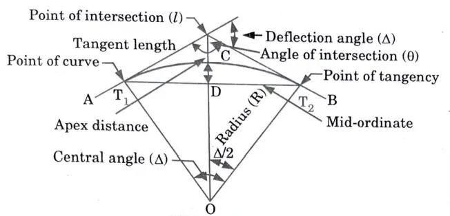
Q7. Explain the elements of simple curve, with neat sketch.
Ans.
Q8. Discuss the uses of transition curve.
Ans. In order to enable a simple and smooth shift in direction, transition curves are frequently employed in railway lines between the circular curve and a tangent.
Q9. Which type of transition curve is used in highway alignment?
Ans. Highway alignment frequently uses spiral turns.
Q10. What is the requirement of transition curve ?
Ans. The radius of curvature at every point on a transition curve must be inversely proportional to the length of the curve, or “l” from the starting point.
Unit 03 Modern Field Survey Systems Notes and Quantum
Q1. Define EDM.
Ans. EDM is a surveying tool that uses electromagnetic waves to electrically measure the distance between two points.
Q2. Write down the types of EDM instruments.
Ans. Following are the types of EDM instruments :
- i. Microwave instruments.
- ii. Visible light instruments.
- iii. Infrared instrument.
Q3. Define the total station.
Ans. An electronic theodolite and an electronic distance metre are combined to form a complete station (EDM).
Q4. What are the advantages of total station?
Ans. Following are the advantages of total station:
- i. Relatively quick collection of information.
- ii. Multiple surveys can be performed at one set-up location.
- iii. Layout of construction site quickly and efficiently.
Q5. Write short notes on orbital calendar and spatial resolution.
Ans. Orbital Calendar: Throughout its orbit, a satellite travels over different regions at various times. An orbital calendar indicates the date that will cover that specific place on the calendar.
Spatial Resolution: In ground dimensions, it is equal to the size of a pixel. A size of 30 m corresponds to a square ground area of 30 m x 30 m. It also refers to the image’s pixel density, measured in pixels per inch.
Q6. Describe the satellite navigation system.
Ans. It was made up of a network of satellites that broadcast radio waves. When receiving these transmitted signals, properly equipped aircraft may calculate their three-dimensional position, velocity, and time.
Q7. What is GPS?
Ans. An unhindered line of sight to four or more GPS satellites is required for the Global Positioning System (GPS) to work, which is a space-based satellite navigation system that gives location and timing information in all weather circumstances anywhere on or near the globe.
Q8. Define image histogram.
Ans. It is a graphic representation of an image’s brightness levels. The brightness levels and frequency of occurrence of each value in the image are represented on the X-axis and Y-axis, respectively.
Q9. Identify the three segments of GPS.
Ans. Following are the segment of GPS :
- i. GPS satellite constellation or space segments.
- ii. Operational control segments (OCS).
- iii. User equipment segments.
Q10. Classify the sources of errors.
Ans. Following are the sources of errors :
- i. Satellite related errors.
- ii. Propagation medium related errors.
- iii. Receiver related errors.
Q11. Write the advantages of DGPS.
Ans. Following are the advantages ofDGPS:
- i. Improved accuracy.
- ii. The majority of the natural and human-made errors that contaminate standard GPS measurements are eliminated by DGPS.
Q12. Compare kinematic and differential GPS systems.
Ans.
| S. No. | Differen.tial GPS | Kinematic GPS |
| i. | Inexpensive. | Expensive. |
| ii. | This method’s accuracy is on the order of a sub-meter. | This method provides centimeter-level precision. |
| iii. | DGPS uses only GPS pseudo ranges to compute its position. | It also makes use of carrier phase, Doppler data, and pseudo ranges. |
Q13. What are the different uses of GPS ?
Ans. Following are the uses of GPS :
i. For navigation purpose. ii. For surveying.
Ill. In remote sensing. iv. In mapping.
v. In military and space. vi. In agriculture, etc.
Q14. Write the use of GPS in remote sensing.
Ans. Additionally, GPS tracking can be used with techniques for remote sensing like photogrammetry, aerial scanning, magnetometry, and video technology.
Q15. Give the functions of GPS satellite signals.
Ans. A GPS satellite signal displays the user’s three-dimensional position along with the current time.
Q16. Define GIS.
Ans. In order to solve challenging planning and management issues, GIS is a system of hardware, software, and processes that supports the collection, management, modification, analysis, modelling, and display of geographically referenced data.
Q17. Discuss the advantages of GIS.
Ans. Following are the advantages of GIS :
i. GIS can handle massive, heterogeneous, multi-layered, spatially referenced data.
ii. GIS can process data quickly, generate results almost instantly, and respond to related questions about the subject.
Q18. What are the components of GIS ?
Ans. Following are the components of GIS :
i. Hardware. ii. Software.
iii. Procedure. iv. Data.
v. Users.
Q19. What do you understand by spatial data model ?
Ans. It is a map of the world that connects geographical features using a coordinate system. While not in digital form, geographic data from maps and images is spatially placed in digital format when it is integrated into a GIS..
Q20. What is data acquisition ?
Ans. Data acquisition is the process of gathering spatial data from readily available sources, such as maps and photographic images, and digitizing it.
Q21. How can you classify raster data ?
Ans. In the raster data structure, everything is represented by grid cells, a point is represented by a single cell, a line by a string of cells and an area by a group of cells.
Q22. What are the hardware components of a GIS ?
Ans. Following are the hardware components of GIS :
i. CPU: Storage capacity for data and programmes is provided by the disc drive, which is connected to the central processor unit.
ii. Digitizer: It is a tool for digitizing information from maps and papers (Raster to vector).
iii. Plotter: Plotter is used to present the result of the data processing on a paper.
iv. Tape Drive: Data or programmes are kept on magnetic tape for use in connecting to other systems.
v. VDU: Display Unit Visual It is utilised to operate various peripherals as well as the computer. It is also known as a workstation or a terminal.
Q23. What are the different uses of GIS ?Ans. As it can be used for management and planning that may be necessary in any field, such as urban planning, forestry, environmental management, flood control, natural disaster management, etc., the range of GIS applications is limitless.
Unit – 4 (Photogrammetric Survey)
Q1. What is photogrammetric survey ?
Ans. It is the science and practise of taking precise measurements from photographs for a variety of uses, including creating topographic and planimetric maps, classifying soils, interpreting geology, gathering military intelligence, and creating composite images of the ground.
Q2. Define aerial survey.
Ans. Aerial photography involves collecting pictures from the air and creating maps or getting the data you need from these maps. Aerial survey or aerial photogrammetry are other names for it.
Q3. Mention the different types of aerial survey.
Ans. Following are the types of aerial survey :
i. Terrestrial photography. ii. Aerial photography.
Q4. Explain stereoscopy.
Ans. It is a method for increasing or creating the depth illusion in a picture when used with binocular stereo.
Q5. How is an aerial photography taken ?
Ans. With the use of a camera installed on the aircraft, an aerial photograph is taken while flying along specified lines known as flight lines and at predetermined height typically at regular intervals.
Q6. Explain flight planning ?
Ans. It involves creating a flight plan that details a potential aircraft flight.
Q7. Give any three advantages that aerial photography offers over ground based observations.
Ans. Following are the advantages of aerial photography :
i. Inaccessible areas.
ii. Mountainous region with less vegetation.
iii. Mapping large areas is faster and economical.
Q8. Explain the disadvantages of aerial photograph.
Ans. Following are the disadvantages of aerial photograph :
i. Not cost-effective for small-area surveys.
ii. Due to the difficulties in distinguishing items on the shot, dense woodlands and flat sands are not ideal.
Q9. Explain relief displacement.
Ans. Relief displacement is the difference on a photograph between the image of any ground point and its image, if the point is projected to a datum plane. This difference is brought on by topographic relief or elevation.
Q10. What is drift in aerial survey ?
Ans. Strong winds frequently cause aircraft to depart from their intended flight paths as photographers work.
Q11. Explain parallax.
Ans. The term “parallax” refers to the displacement in an object’s picture brought on by a change in the point of observation, or by subsequent exposures made while in flight.
Q12. What is the use of parallax bar ?
Ans. The parallax difference between two points is calculated using it. The term “parallax difference” refers to the difference in parallax between two places.
Q13. List the characteristics of photographic image.
Ans. Characteristics of photographic image can be divided into two categories :
i. Qualitative Characteristics: These include the photographic image’s shape, size, tone, texture, and pattern.
ii. Quantitative Characteristics: Photographic images’ regions, separations, inclinations, and heights fall under this category.
Q14. Explain advantages of digital photogrammetry.
Ans. Following are the advantages of digital photogrammetry:
- i. It facilitates direct production of digital maps.
- ii. Other non-traditional sources, such LIDAR, digital camera output, etc., can be used as inputs.
- iii. Except for two types of instruments, it doesn’t need any routine maintenance.
Unit – 5 (Remote Sensing and Digital Image Processing)
Q1. Define remote sensing.
Ans. Remote sensing is the process of learning about a subject without physically touching it. Another name for aerial photography is remote sensing.
Q2. Which type of energy is used in remote sensing ?
Ans. Remote sensing makes use of electromagnetic energy, often known as light energy.
Q3. What is spectral signature ?
Ans. To determine the object’s general reflectance properties across various wavelength intervals, the patterns are averaged. The term “spectral signature” refers to the representation of such an averaged reflectance.
Q4. Explain resolution.
Ans. The ability of a remote sensing device to record data of the smallest discrete quantities in terms of size (spatial), spectral band of electromagnetic radiation (radiation strength), and time is known as resolution.
Q5. What are the characteristics of ideal remote sensing system?
Ans. Following are the characteristics of ideal remote sensing system :
- i. Uniform electromagnetic energy source.
- ii. Series of unique energy.
- iii. Non-interfering atmosphere.
- iv. Super sensor, etc.
Q6. What is atmospheric windows ?
Ans. electromagnetic radiation with a long wavelength that is highly transmissive through the atmosphere. are referred to as atmospheric windows.
Q7. Explain geosynchronous satellites.
Ans. A geostationary satellite is an earth-orbiting spacecraft that is positioned straight over the equator at a height of about 35,800 km and rotates in the same direction as the earth. At this altitude, one orbit takes 24 hours, or the time it takes the earth to complete one full rotation of its axis. The term “geostationary” refers to how a satellite of this type looks to an observer on the ground to be almost stationary in the sky.
Q8. Explain sun-synchronous satellite .
Ans. These satellites are at low altitudes (300–1000 km). Satellites placed in near polar orbit such that pass over the same area of the earth at same local solar time every day.
Q9. Give the applications of Indian Remote Sensing (IRS).
Ans. Application : Indian Remote Sensing (IRS) satellite imagery has been used in a variety of industries, from urban planning to agriculture.
Example : Crop health monitoring, Crop yield estimation and drought assessment.
Q10. Explain spectral reflectance curve.
Ans. Spectral Reflectance Curve : It shows a graph between an object’s spectral reflectance and wavelength.
Utilities : To determine what feature is present at given place in an aerial photograph, spectral reflectance curves are utilized to compare the aerial photograph recorded with them.
Q11. Explain active and passive remote sensing.
Ans.
| S. No. | Active RSS | Passive RSS |
| i. | It produces, uses, and captures its own energy to illuminate the target and capture the energy reflected back. | They rely on solar radiation to cast light on the object. |
| ii. | The electromagnetic spectrum’s microwave range is where these systems function. | They function in the electromagnetic spectrum’s visible and infrared range. |
| iii. | Their wavelengths are longer than one mm. | Their wavelengths range from 0.4 to 10 µm. |
| iv. | Example : Synthetic aperture radar. | Example : Any electromagnetic remote sensing system (Camera without flash light). |
Q12. Describe attribute data.
Ans. Data with a quality feature (or attribute) that satisfies or fails to satisfy a product standard is referred to as attribute data. These qualities can be grouped and quantified. The amount of flaws (defects) in a specific product and the number of nonconforming pieces are two examples of attribute data (defectives).
Q13. What do you mean by digital image processing ? Ans. The task of processing and interpreting digital data using an image processing method is known as digital image processing. To obtain images that closely resemble the original geometry of the earth and brightness values that closely like the radiation from the relevant feature, digital image processing is used.

Surveying And Geomatics Quantum, Syllabus, Important Questions
| Label | Link |
|---|---|
| Subject Syllabus | Syllabus |
| Short Questions | Short-question |
| Important Unit-1 | Unit-1 |
| Important Unit-2 | Unit-2 |
| Important Unit-3 | Unit-3 |
| Important Unit-4 | Unit-4 |
| Important Unit-5 | Unit-5 |
| Question paper – 2021-22 | 2021-22 |
Surveying And Geomatics Quantum PDF: | AKTU Quantum PDF:
| Quantum Series | Links |
| Quantum -2022-23 | 2022-23 |
AKTU Important Links | Btech Syllabus
| Link Name | Links |
|---|---|
| Btech AKTU Circulars | Links |
| Btech AKTU Syllabus | Links |
| Btech AKTU Student Dashboard | Student Dashboard |
| AKTU RESULT (One VIew) | Student Result |