
Boost Your Exam Preparation: AKTU B.Tech Surveying and Geomatics Unit 04 Q/A Notes on Photogrammetric Survey
Dudes 🤔.. You want more useful details regarding this subject. Please keep in mind this as well.

Important Questions For Surveying And Geomatics:
*Unit-01     *Unit-02
*Unit-03    *Unit-04
*Unit-05    *Short-Q/Ans
*Question-Paper with solution 21-22
Q1. What do you understand by the term ‘Aerial photography’ ? Also write a short note on the factors that influence aerial photography.
Ans. A. Aerial Photogrammetry: It belongs to the category of photogrammetry in which images are captured by a camera placed on an aeroplane that is flying over the scene.
B. Advantages : Following are the advantages of aerial photogrammetry :
- 1. Suitable for inaccessible areas.
- 2. Suitable for mountainous region with less vegetation.
- 3. Suitable for mapping large areas, faster and economical.
C. Disadvantages : Following are the disadvantages of aerial photogrammetry :
- 1. Due to the difficulties in distinguishing items on the images, dense woodlands and flat sands are not acceptable.
- 2. Not economical for survey of small areas.
Factors : Following are the factors that influence aerial photography :
1. Atmospheric Conditions : The optimal time to take pictures is when there aren’t any airborne particles (like smoke or dust) or gas molecules because these tend to scatter light and lessen contrast. During clear skies (November-February).
2. Scale : Ratio of flh (f-focal length of the camera lens and h-flying height above the mean terrain). Due to variations in flying height, the scales of different photographs may vary. Scale may also vary because of the effects of tilt and relief displacements.
3. Camera/Film/Filter Combination : Modern cameras with little distortion are utilised to assure high image quality. Different lens/focal length/film/filter combinations might be utilised depending on the needs.
4. Flight Direction : The target area is covered by strips of aerial photography. The number of strips should be kept to a minimum. As a result, the strips’ flying direction is maintained across the entire space.
5. Time/ Season of Photography : When the sun is 30 degrees above the horizon or three hours before and after local noon, aerial photography should be flown.
Q2. Differentiate between ‘Aerial photography’ and ‘Aerial photogrammetry’.
Ans.
| S. No. | Aerial Photography | Aerial Photogrammetry |
| 1. | The skill of taking and editing pictures from above is known as aerial photography. | The technology of taking measurements from images is called aerial photogrammetry. |
| 2. | The fundamental principle used by photography is line of sight. | Triangulation is the essential idea of photogrammetry. |
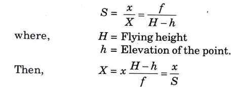
Q3. Derive an expression for the scale of vertical photograph.
Ans. A. Scale of Aerial Photograph :
- 1. Scale of a vertical photograph = Distance on photo / Corresponding Distance on ground
- 2. Because a map is an orthographic projection, the scale is consistent throughout the entire map, whereas a photograph is a perspective projection, therefore the scale fluctuates owing to changes in terrain elevation.
- i. Flat Terrain: The Fig. shows a flat terrain AB height h above datum.
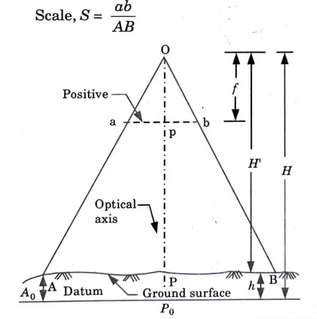
From similar triangles Oap and OAP,
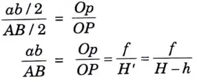
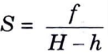
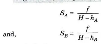
ii. Variable Terrain: Fig. shows the vertical photograph of a terrain, m which the elevation is not constant. As per formula S=f/(H-h), the scale increases with increase in elevation. Consider two points A and B, hA and hB above datum respectively.
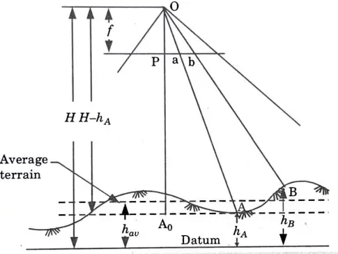
B. Average Scale :
1. For a variable terrain it is often convenient to express average scale of the photograph; If elevation of points A, B, C, D ….. is hA, hB, hC, hD ….
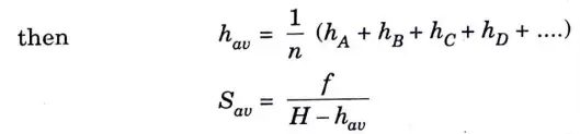
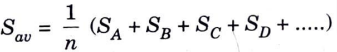
2. Average scale of a terrain can also be obtained by determining scale of different points and taking their average.
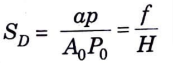
C. Datum Scale (SD):
1. A vertical photograph’s datum scale is the scale that would result from projecting all of the ground points downward onto the datum.
2. From Fig.
Q4. Explain how the ground coordinates and the distances can be obtained from a vertical photograph.
Ans. B. Coordinate and Distances of Vertical Photograph :
1. Let photo co-ordinates of a point be (x, y) and ground co-ordinates of corresponding point (X, Y) then from scale of a photograph
2. If there are two points A an.dB on the ground with elevations hA and hB . then their ground co-ordinates are :
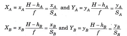
3. Distance between two points by co-ordinate geometry,
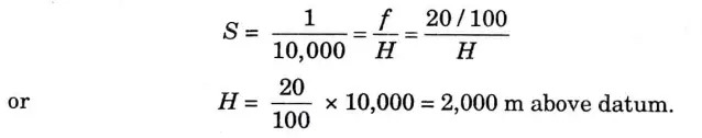
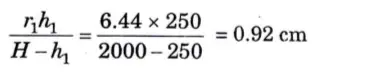
Q5. The distance from the principal point to an image on a photograph is 6.44-cm and the elevation of the object above datum is 250 m, what is the relief displacement of the point is datum is 1/10000 and focal length is 20 cm.
Ans. Given : Elevation of the object, h1 = 250m.
Distance between principal point to image on photograph, r1 = 6.44cm
Scale, S = 1 : 10000, Focal length, f = 20cm
To Find : Relief displacement
1. Scale of photograph is given by,
2. Relief displacement =
Q6. Why overlapping is necessary ?
Ans. A. Overlap : There should be some overlap between the areas covered by each aerial shot in order to guarantee full coverage of the survey region. Following are the two types of overlap :
1. End or Longitudinal or Forward Overlap : It is the overlap in photographs in the direction of flight. It is kept 55 % to 65 %.
2. Side Overlap :
- i. It is the overlap in photograph in a direction perpendicular to the line of flight. It is kept 25 % to 35 %.
- ii. It is the overlap between photographs of two adj acent flight strips. It is also called “lateral overlap”.
B. Requirements of Overlapping :
- 1. Prints must be oriented to provide a continuous flying strip.
- 2. The centre of the print is consistently less warped than the corners. The severely deformed outside portion of the shot can therefore be disregarded because, due to the overlap, the same region is taken twice or three times.
- 3. Only the overlapped portion is relevant for stereoscopic vision.
- 4. If a correct side overlap is offered, there won’t be any gaps created if the aircraft deviates from the flight path.
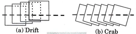
C. Drift : It is the moving of aircraft from their intended flight paths, which is frequently caused by severe winds (while taking photographs).
D. Crab : The photograph will be taken obliquely to the direction of flight if the camera installed outside an aircraft is not square with the direction of flight at the time of exposure.

Surveying And Geomatics Quantum, Syllabus, Important Questions
| Label | Link |
|---|---|
| Subject Syllabus | Syllabus |
| Short Questions | Short-question |
| Important Unit-1 | Unit-1 |
| Important Unit-2 | Unit-2 |
| Important Unit-3 | Unit-3 |
| Important Unit-4 | Unit-4 |
| Important Unit-5 | Unit-5 |
| Question paper – 2021-22 | 2021-22 |
Surveying And Geomatics Quantum PDF: | AKTU Quantum PDF:
| Quantum Series | Links |
| Quantum -2022-23 | 2022-23 |
AKTU Important Links | Btech Syllabus
| Link Name | Links |
|---|---|
| Btech AKTU Circulars | Links |
| Btech AKTU Syllabus | Links |
| Btech AKTU Student Dashboard | Student Dashboard |
| AKTU RESULT (One VIew) | Student Result |