In this blog article Surveying and Geomatics Unit 01, we’ll look at the significance of Unit 01 in Surveying and Geomatics, as well as go deeper into the most important topics that students should be familiar with. Whether you’re a skilled professional or just getting started, this book is a must-have for any Surveying and Geomatics student.
Dudes 🤔.. You want more useful details regarding this subject. Please keep in mind this as well.

Important Questions For Surveying And Geomatics:
*Unit-01     *Unit-02
*Unit-03    *Unit-04
*Unit-05    *Short-Q/Ans
*Question-Paper with solution 21-22
Q1. What is surveying ? Explain the importance of surveying in civil engineering.
Ans. A. Surveying: By using either direct or indirect measurements of distance, direction, and elevation, it is the process of identifying the relative positions of locations on, above, or below the surface of the earth with relation to one another.
B. Importance:
- 1. Surveying measures serve as the foundation for the planning and design of all civil engineering projects, such as the building of roads, bridges, tunnels, dams, etc.
- 2. Any size project is built along the lines and points determined by surveying.
- 3. State and federal borders are fixed through surveying.
- 4. Coastal boundaries, lakes, and navigable streams are mapped using surveys.
- 5. Hydrographic and oceanographic charting and mapping are carried out using surveying.
- 6. Surveying is used to create a topographic map of the earth’s land surface.
Q2. Classify surveying on the basis of instruments used and name all equipments necessary for the field work involving any one of them.
Ans. A. Based on Instrument Used :
1. Chain Survey: When designing a relatively tiny open field, the fieldwork might merely involve taking linear measurements. A chain and tape are used for all measurements.
2. Levelling: This method of surveying uses a level and graduated staff to determine the relative vertical heights of the points.
3. Plane Tabling: It is a graphical surveying method where plotting and field operations are done simultaneously.
4. Triangulation: Triangulation is used when a large area needs to be surveyed. The entire space is partitioned into a network of triangles in this.
5. Electromagnetic Distance Measurement (EDM) Survey: The transmission, reflection, and subsequent reception of either light or radio waves are used in this technological method of determining distance.
6. Total-station Survey: Total stations are made up of electronic theodolites, EDMs, and electronic data collectors.
7. Satellite Based Survey: Remote sensing and global positioning system (GPS) are the satellite-based surveys.
B. Based on Purpose of Survey :
1. Engineering Survey: Engineering surveys are those that are carried out to gather enough information for the design of engineering projects like roads, trains, water supply, sewage disposal, reservoirs, bridges, etc.
2. Defense Survey: The military uses surveys in a very vital and important way. They offer strategic data that can determine how a battle will unfold.
3. Geological Survey: To ascertain the location, scope, and reserves of various minerals and rock types, surface and subsurface surveying are needed in this.
4. Geographical Survey: Geographical surveys are ones that are carried out to collect enough information for the creation of geographic maps.
C. Based on Place of Survey:
1. Land Survey: This is used to establish the limits and areas of land parcels. Among the several types of land surveying are topographical, city, and cadastral surveys.
2. Hydrographic Survey: It focuses on the survey of water bodies including lakes and streams. coastal waters and involves gathering information to map the borders of water basins.
3. Underground Survey: Setting the location and routes of tunnels, shafts, and drifts, among other things, is referred to as the development of underground plans.
4. Aerial Survey: Aerial or photogrammetric surveying refers to the process of taking images with a camera mounted on an aircraft.
Q3. Explain and describe the fundamental principles of surveying.
Ans. Basic Principle of Surveying: Following are the basic principles of surveying:
- 1. To work from whole to part.
- 2. To locate a point by at least two measurement.
1. To Work from Whole to Part:
- i. Working from whole to part is the primary principle of surveying, and a method that violates this principle should not be used unless there is no other option.
- ii. Working from whole to part has as its major goal the localization of errors and the prevention of their accumulation.
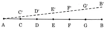
- iii. By designating a point C as C’ by judgement or by a process of ranging with respect to A and B, the endpoints, a portion, say AC, of the entire distance AB to be measured is fixed.
- iv. Then the other points D, E, F, etc.; are fixed with respect to A and C’ (part AC).
- v. Now if point Cis not in linewithAB, all the pointsD,E,F, etc., established will be out of line with an increasing magnitude of error.
- vi. The length measured will, therefore, be incorrect to a larger extent as compared to the direct method.
- vii. This method may introduce serious error as the survey at the end becomes uncontrollable and hence working from part to whole is never recommended.
- viii. The plane table surveying, however, is an example of working from part to whole.
2. To Locate a Point by at Least Two Measurement :
- i. Any two significant characteristics are chosen as the control sites, and their distances are precisely measured.
- ii. The line joining the control points is plotted to the scale on drawing sheet.
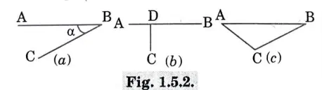
- iii. Now the desired point can be plotted by making two suitable measurements from the given control points. Let A and B be the two control points, whose positions are already known on the plan. The position of C can be plotted by any of the following methods :
- a. By measuring distance BC and angle a, as shown in Fig. 1.5.2(a).
- b. By dropping a perpendicular from Con the line AB and measuring either AD and CD or BD and CD, as shown in Fig. 1.5.2(b).
- c. By measuring the distances AC and BC, as shown in Fig. 1.5.2(c).
Q4. Explain clearly the difference between a prismatic compass and surveyor’s compass.
Ans.
| S. No. | Prismatic Compass | Surveyor’s Compass |
| 1. | It consists of prism. | It does not have prism. |
| 2. | It gives whole circle bearing. | It gives quadrantal or reduced bearing. |
| 3. | Graduations are marked from oo to 360° in this type of compass. | It is divided into four quadrants and graduations are marked from 0° to 90° in each quadrant. |
| 4. | Without moving the eye, it is possible to sight and read at the same time. | Reading and sighting cannot be done at the same time without the eye position being altered. |
| 5. | It does not rotate with the line of sight. | It can rotate with the line of sight. |
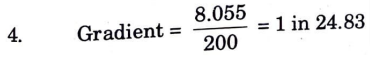
Q5. The following successive staff readings were taken with a level using 5 m leveling staff on a continuously sloping ground at an interval of 25 m : 0.405, 1.035, 1.930, 2.895, 3.805, 4. 760, 0. 715, 2.060, 3.160, 4.415 The reduce level of the first point is known to be 62.980 m. Workout the staff reading by height of instrument method and find the gradient of the line joining the first and the last points.
Ans. Given : Staff interval = 25m, RL of first point = 62.980 m
To Find : RL of various points and gradient of line joining the first and last point.
1. The reduce level of points are calculated by HI method and tabulated in table
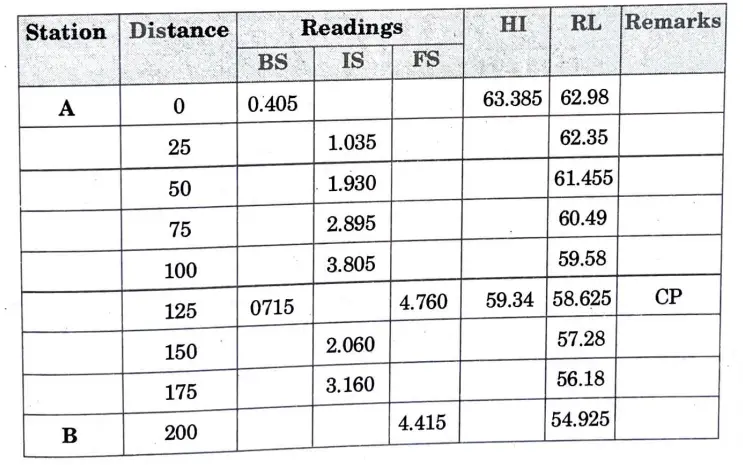
2. Arithmetic Checks :
Σ BS- Σ FS = 1.12- 9.175 =-8.055 m
RL of last point- RL of first point= 54.925 – 62.98 =- 8.055 m
3. There is a full of 8. 055 m in a distance of 200 m
Q6. Which are the methods of plane tabling, enlist them with their definition and explain the procedure for any one of them.
Ans. Methods of plane tabling are as follows :
1. Radiation :
- i. When the distances between the plane table station and the objects are within a tape length, this method is used.
- ii. Once the table is in place, a ray is created while the alidade is pointed in the direction of the object to be plotted, its straight (fiducial) edge contacting the position of station on the sheet that the plane table occupies.
- iii. Measure the distance of the object from the plane table station and plot it on the sheet to scale along the ray drawn.
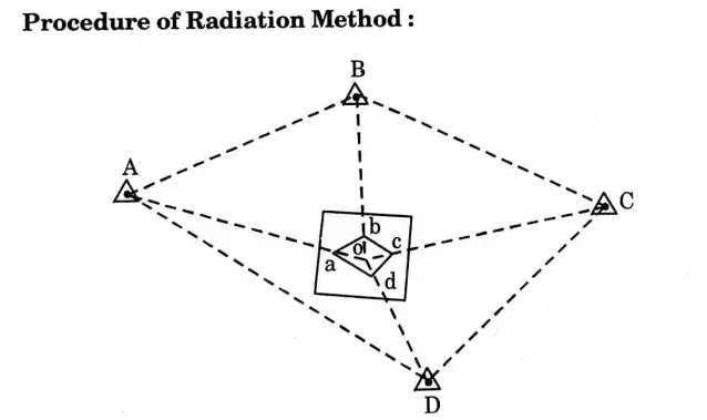
- i. Select a station o such that all the other stations A, B, C and D are accessible and visible from o.
- ii. Plot the N-S direction. Setup a plane table at o.
- iii. Place the alidade at o and successively sight stations A, B, C and D.
- iv. Draw rays from o to the stations and cut the distances oa, ab, oc and od to the chosen scale.
- Join a, b, c and d.
2. Intersection :
- i. When the distances between the plane table station and the objects are either too great or cannot be measured precisely because of certain field circumstances, this method is used.
- ii. For this method position of at least two stations should be available on the drawing sheet.
- iii. The line joining the two stations is called base line.
- iv. Other plane table stations can also be found using this technique, however the point should be found via the intersection of three or more rays.
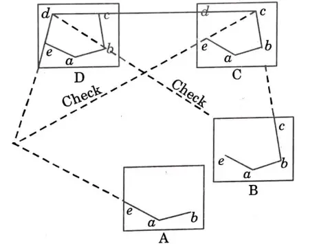
3. Traversing :
- 1. Traversing is the word for using the radiation method to draw the plane table stations of a closed or open traverse.
- ii. Diagonals are used as check lines.
- iii. It is most suited when a narrow strip of terrain is to be surveyed.
4. Resection:
- i. When the table fills a station whose position is not yet known on the drawing sheet, resection is the orientation technique used.
- ii. It is done by means of sights towards known points whose location on the sheet is available.
- iii. If the orientation at the station to be plotted is correct, which is rarely the case, the point representing the station to be located will be the point formed by the resection of two rays.
- iv. This technique is used when the surveyor notices that certain crucial information may be conveniently plotted by selecting a station other than the triangulation stations during the survey.
- v. Due of how local attraction affects the precision of orientation, this strategy is not chosen if one of the other two may be employed.
- vi. However, this method is generally used for rapid and approximate orientation before final orientation by other methods.
- vii. Since this approach is not dependent on a magnetic compass, it is unaffected by magnetic localization. It is crucial that lines be drawn using the same alidade edge. It is possible to guarantee that the back ray stays vertically above the front station’s ground position.

Surveying And Geomatics Quantum, Syllabus, Important Questions
| Label | Link |
|---|---|
| Subject Syllabus | Syllabus |
| Short Questions | Short-question |
| Important Unit-1 | Unit-1 |
| Important Unit-2 | Unit-2 |
| Important Unit-3 | Unit-3 |
| Important Unit-4 | Unit-4 |
| Important Unit-5 | Unit-5 |
| Question paper – 2021-22 | 2021-22 |
Surveying And Geomatics Quantum PDF: | AKTU Quantum PDF:
| Quantum Series | Links |
| Quantum -2022-23 | 2022-23 |
AKTU Important Links | Btech Syllabus
| Link Name | Links |
|---|---|
| Btech AKTU Circulars | Links |
| Btech AKTU Syllabus | Links |
| Btech AKTU Student Dashboard | Student Dashboard |
| AKTU RESULT (One VIew) | Student Result |
3 thoughts on “Unit 01 : Important Question in Surveying And Geomatics AKTU Btech.”