With Aktu Btech Quantum Notes, you may improve your preparation for Engineering Hydrology. To succeed on your examinations, access essential, recurrent questions and comprehensive content. Improve your comprehension right away! Unit-4 Groundwater
Dudes 🤔.. You want more useful details regarding this subject. Please keep in mind this as well.

Important Questions For Engineering Hydrology:
*Quantum                *B.tech-Syllabus
*Circulars                 *B.tech AKTU RESULT
* Btech 3rd Year      * Aktu Solved Question Paper
Q1. Discuss briefly as to how the water is stored into the groundwater reservoir. Briefly mention the various zones and importance of the zone of saturation in this connection.
Ans. A Occurrence of Subsurface Water (Groundwater):
Water in the soil mantle is called subsurface water and is considered in two zones:
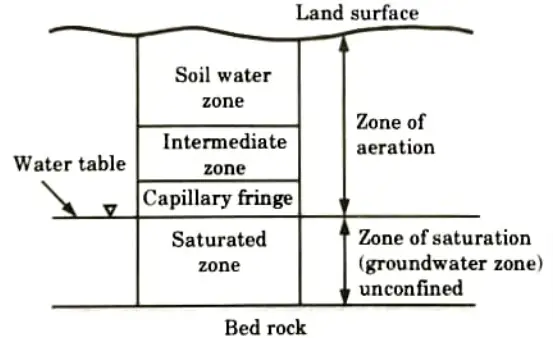


- 1. Saturated Zone: This zone, also known as the groundwater zone, is the region where all of the soil pores are filled with water. The water table serves as its upper limit and denotes a free surface, i.e. a surface subject to air pressure.
- 2. Zone of Aeration: The soil pores are only partially saturated with water in this zone. This zone is defined by the distance between the land surface and the water table. The aeration zone is divided into three subzones:
- i. Soil Water Zone: This is located near the ground surface in the primary root band of the vegetation, from which water is lost to the atmosphere by evapotranspiration.
- ii. Capillary Fringe : Capillary action holds the water in this case. This zone stretches upwards from the water table to the capillary rise limit.
- iii. Intermediated Zone:
- a. This lies between the soil water zone and the capillary fringe.
- b. The thickness of the aeration zone and its constituent subzones is determined by soil texture and moisture content and varies by region. Soil moisture in the aeration zone is critical in agricultural practise and irrigation engineering.
B. Saturated Formation:
- 1. Pore gaps exist in all earth materials, from soils to rocks.
- 2. Despite the fact that these pores are totally saturated with water below the water table, from the standpoint of groundwater consumption, only materials through which water moves freely and hence can be retrieved easily are significant.
- 3. On this basis the saturated formations are classified into four categories:
- i. Aquifer:
- a. It is a saturated formation of earth material that not only holds but also yields a significant amount of water. As a result of its high permeability, an aquifer can carry water very quickly.
- b. Unconsolidated sand and gravel deposits form good aquifers.
- ii. Aquitard:
- a. It is a formation that allows only seepage, hence the yield is small when compared to an aquifer.
- b. It is partially permeable. Aquitard is a type of sandy clay unit.
- c. Significant amounts of water may flow through an aquitard to an aquifer beneath it.
- iii. Aquiclude:
- a. It is a geological formation that is essentially impervious to water flow.
- b. Due to its high porosity, it may be deemed closed to water movement even though it may hold huge amounts of water. An aquiclude is something like clay.
- iv. Aquifuge:
- a. It is a type of geological formation that is neither porous nor permeable.
- b. Because there are no connecting apertures, it cannot transport water.
- c. An aquifuge is a massive, compact rock with no fissures.
Q2. Explain in detail about the forms of subsurface water with neat sketch.
Ans. Forms of Subsurface Water: The underground water is generally available in the following forms:
1. Infiltration Galleries:
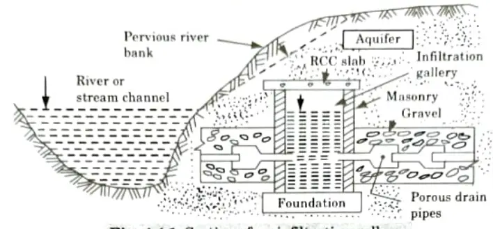
- i. They are horizontal or almost horizontal tunnels built at shallow depths (3 to 5 metres) along the river’s bank through water-bearing layers, as illustrated in Fig. These are also known as horizontal wells.
- ii. These galleries are typically made of masonry walls with roof slabs, and they get their water from the aquifer via a network of permeable drain pipes.
- iii. These pipes are typically covered with dirt to prevent fine sand particles from entering the pipe.
- iv. These tunnels or galleries are typically built on a slope, and the water collected in them is pumped to a sump well, where it is treated and given to consumers.


2. Infiltration Wells:
- i. These are the shallow wells built in series along river banks to collect river water seeping through their bottoms, as seen in Fig (a).
- ii. These wells are often built of brick masonry with open joints, with the top covered and the bottom left uncovered, as illustrated in Fig (b). Manholes are installed in the top cover for inspection purposes.
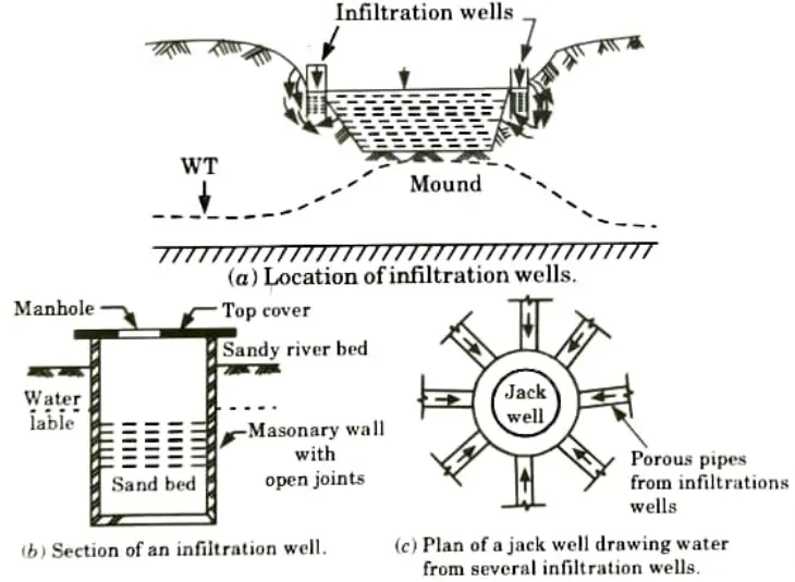


- iii. As shown in Fig.(c) the numerous infiltration wells are linked by porous pipes to a sump well known as a jack well . Water from various infiltration wells is hoisted, processed, and provided to consumers via the jack well.
3. Springs: A spring is the natural outpouring of groundwater at the Earth’s surface. Natural spring is created by a pervious layer wedged between two impervious ones.
Types of Springs:
- i. Gravity Springs: A gravity spring is generated when the ground water table rises high and the water spills over the sides of a natural valley or depression.
- ii. Surface Springs:When an impermeable obstacle or stratum supporting subsurface storage becomes sloped, the water table rises and becomes exposed to the ground surface. A surface spring is the name given to this sort of spring.
- iii. Artesian Springs: The spring formed when the storage is under pressure (i.e., the water is flowing through some constrained aquifer) is known as an artesian spring. These springs are also used to provide a very uniform amount of water.
4 Wells: A water well is a vertically excavated hole in the earth used to bring groundwater to the surface for drinking.
The wells may be classified into two types :
i. Open Wells:
- a. They are often open masonry wells with larger diameters that are suited for low discharges of 1-5 litres per second.
- b. The diameter of open wells ranges from 2 to 9 m, and their depth is usually less than 20 m.
- c. An open well’s walls might be made of precast concrete rings or of brick or stone masonry.
Type of Open Wells: The open wells may be classified into the following two types:
- a. Shallow open wells.
- b. Deep open wells.


ii. Tube Wells:
- a. The discharge rate from an open well is typically limited to 3 to 6 litres per second.
- b. Mechanical pumping of minor discharges accessible in open wells is a. not cost effective.
- c. To produce a big discharge mechanically, a tube well is bored or drilled deep into the ground, intercepting one or more water bearing stratum.
Types of Tubewells: The tubewells can be broadly classified into the following two categories:
- a. Cavity type tubewells.
- b. Screen tubewells.
Q3. Describe various types of tubewells.
Ans. Types of Tubewells: Following are the various types of tubewells :
1. Strainer Type Tubewell:
- i. The most popular and commonly used well is the strainer well. The phrase “tube well” generally refers to the strainer kind of tube well.
- ii. A strainer, which is a unique form of wire mesh, is wrapped around the main tube of the well in this sort of well.
- iii. The main pipe has larger holes or slots than the strainer openings.
- iv. The entire area of the tube openings is kept equal to the total area of the strainer apertures so that the flow velocity does not change.
- v. Because of the fineness of the strainer apertures, a higher operational velocity of water is possible.
- vi. Little annular space is left between the strainer and the pipe so that the open area of pipe perforations is not reduced.
- vii. A strainer well can draw water from either an unconfined aquifer with an infinite depth or from one or more confined aquifer layers.
- viii. Strainers are only provided for the length of the pipe that crosses the equator.
- ix. The aquifer portion of the pipe is kept perforated. The remainder of the section is made up of plain or blind pipe.
2. Cavity Type Tubewell:
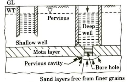
- i. This is a type of tube well in which water is drawn through the bottom of the well where a cavity is produced rather than through the strainer.
- ii. The tube well pipe penetrates a thick clay layer that serves as a sturdy roof. As a result, a cavity tube well is analogous to a deep well.
- iii. A deep well, on the other hand, must draw from the first aquifer below the mota layer, but a cavity well does not.
- iv. A confined aquifer of good specific yield and a strong impermeable material above the aquifer are required for a cavity tube well to perform properly.
- v. During the early stage of pumping using a centrifugal pump or an air lift pump, fine sand is mixed with water, resulting in the formation of a hollow chamber.
- vi. As the radial critical velocity falls and the sand particles stop entering the well, the spherical surface area of the cavity rises outwards.
- vii. At this point, the cavity creation has reached equilibrium, and clean water continues to enter the well with further pumping at the same steady discharge.
- viii. After the cavity forms, the velocity of water entry at the bottom of the pipe is less than the critical.
3. Slotted Type Tube Well:
- i. A slotted tube well is resorted under two circumstances:
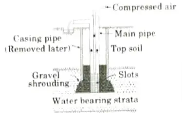


- a. Sufficient depth of water bearing stratum is not available even upto a depth of 75 to 100 m, so that strainer type tube well cannot e used.
- b. Suitable strong roof is not available so that a cavity well cannot be formed.
- ii. In such cases, a slotted well is employed and is designed to penetrate to a certain depth in the water-bearing strata.
- iii. A slotted tube well is essentially a slotted tube that penetrates the limited aquifer.
- iv. Slots with dimensions of 25 mm x 3 mm and spacing of 10 to 12 mm may be used. The pipe is veiled with a mixture of gravel and bajri to prevent fine particles from entering (coarse sand).
Q4. What is the surface of seepage and free surface of curve ?
Ans. Surface of Seepage and Free Surface Curve:
- 1. The free surface is the surface over which air pressure prevails.
- 2. Consider an unconfined aquifer, and let AD be the approximate horizontal location of the original free water surface (i.e., the water table).
- 3. Build a gravity well of radius rw throughout the aquifer’s depth.
- 4. Let d be the height from the well’s bottom to the groundwater table.
- 5. Let water to be pumped from this well. Following the pumping, the water will remain in the remaining bore holes along the lines AB’CD, as there is no groundwater other than capillary moisture.
- 6. But according to the Dupuit’s formula, the water level in the pumped well is not found at B’C’ level, but at a slightly lower than this level, i.e., at BC.
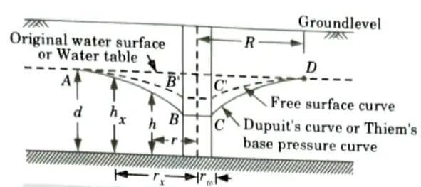


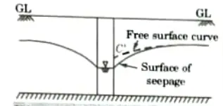


- 7. As a result, the drawdown in the pumped well is somewhat greater than the drawdown in the surrounding groundwater table.
- 8. This is for the well. The vertical ground surface that forms outside of the well hole and is exposed between the water surface in the well and the free surface is known as the “seepage surface “
- 9. The cone of depression or Dupuit’s base pressure curve will be represented by ABCD.
Q5. Express the flow net construction for steady groundwater flow.
Ans. Flow Net for Steady Groundwater Flow:
- 1. For drawing a flow net, the boundary conditions should be known. For a steady state flow, these are as follows:
- i. The line GK and its elongation of the left side, as far as the section extends, is an equipotential line with head H.
- ii. ABC is a flow line.
- iii. The line CJ and its elongation to the right side is an equipotential line with zero head.
- iv, Along the impervious bottom is the last flow line.
- 2. The procedure for drawing the flow net can be divided into the following steps:
- i. The first step. Determine the hydraulic boundary conditions. The upstream bed level GDAR indicates a 100% potential line in Fig., while the downstream bed level MCFJ represents a 0% potential line.
- ii. The first flow KLM embraces the hydraulic structure and is produced by the flow of water on the upstream and downstream sides of the sheet pile, as well as at the contact of the dam’s base and the soil surface.
- iii. Impervious stratum NP denotes the final flow line.
- iv. Draw an atrial flow line ABC along the border line. The line must be perpendicular to both the upstream and downstream beds.
- v. Using equipotential lines, divide the first flow channel into roughly squares beginning at the upstream end. The size of the square should progressively alter.
- vi. Extend the equipotential lines that create the square’s sides downward. These extensions indicate the approximate width of the squares, such as squares (1) and (2).
- vii. Set the other sides of the squares to the widths calculated above. Irregularities are smoothed out, and the next flow line DF is made to connect these bases. Care should be given in sketching the flow line to make flow fields as approximate squares throughout.
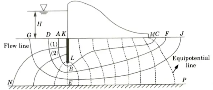


- viii. The equipotential lines are further extended downward, and one more flow line GEJ is drawn, repeating the step (vi).
- ix. If the flow fields in the last flow channel are inconsistent with the actual boundary conditions, the whole procedure is repeated after taking a new trial flow line.
Q6. Explain in detail about well hydraulics.
Ans. Well Hydraulics:
- 1. Wells are in direct hydraulic communication with aquifers; they are used to extract ground water and, in some cases, to recharge aquifers.
- 2. They can estimate aquifer parameters such as the storage coefficient and transmissivity in the region of the well by conducting pumping tests on wells that allow direct access to ground-water conditions.
- 3. The coefficient of storage is a measure of the amount of water obtained as the amount of water given by the aquifer per unit surface area per unit pressure head change (reduction).
- 4. When an aquifer is recharged, the amount of water taken into storage by the aquifer per unit surface area per unit change (increase) in pressure head is defined as s.
- 5. The coefficient of transmissibility, T, is a measurement of the rate at which water flows through an aquifer’s saturated thickness.
- 6. This type of quantitative procedure is frequently referred to as the aquifer performance test, or simply the aquifer test.
- 7. When these aquifer characteristics are known, projected drops in groundwater levels can be used to aid in resource management and environmental conservation.


Important Question with solutions | AKTU Quantums | Syllabus | Short Questions
Engineering Hydrology Btech Quantum PDF, Syllabus, Important Questions
| Label | Link |
|---|---|
| Subject Syllabus | Syllabus |
| Short Questions | Short-question |
| Question paper – 2021-22 | 2021-22 |
Engineering Hydrology Quantum PDF | AKTU Quantum PDF:
| Quantum Series | Links |
| Quantum -2022-23 | 2022-23 |
AKTU Important Links | Btech Syllabus
| Link Name | Links |
|---|---|
| Btech AKTU Circulars | Links |
| Btech AKTU Syllabus | Links |
| Btech AKTU Student Dashboard | Student Dashboard |
| AKTU RESULT (One View) | Student Result |
