
Latest B.Tech. AKTU Quantum Book Short Question Notes on Engineering Hydrology are revealed. Investigate the concepts of the water cycle, rainfall analysis, and water resource management for environmentally friendly engineering methods.
Dudes 🤔.. You want more useful details regarding this subject. Please keep in mind this as well.

Important Questions For Engineering Hydrology:
*Quantum                *B.tech-Syllabus
*Circulars                 *B.tech AKTU RESULT
* Btech 3rd Year      * Aktu Solved Question Paper
Unit-I: Introduction to Hydrology (Short Question)
Q1. Define hydrogeologist.
Ans. A hydrogeologist is someone who focuses on understanding where, how, and how underground water flows. They employ their knowledge to locate fresh groundwater resources and to preserve the quantity and quality of the ones that already exist.
Q2. What is meant by hydrologic cycle ?
Ans. The process of water moving from the atmosphere to the earth in the form of precipitation, being transported by streams and rivers to oceans and lakes, etc., and then being evaporated back into the atmosphere is known as the hydrologic cycle.
Q3. What are the components of hydrological cycle ?
Ans. The hydrological cycle consists of the following processes:
i. Evaporation (E) and transpiration (T). ii. Precipitation (P).
iii. Runoff (R).
Q4. Describe the evaporation and transpiration.
OR
Briefly explain evaporation process.
Ans. Evaporation: It is the process by which heat energy is transferred from a liquid to a gaseous form at the free surface below the boiling point.
Transpiration: This is how water exits a living plant’s body and enters the atmosphere as water vapour.
Q5. Define evapotranspiration.
Ans. The total amount of water lost by plants through evaporation and transpiration is known as evapotranspiration, a phrase that combines the terms evaporation and transpiration.
Q6. What is hygroscopic water ?
Ans. The soil particles securely hold the water that has been taken from the atmosphere, making it impossible for plants to access it in levels that would allow them to thrive.
Q7. Define precipitation. What is cyclonic precipitation ?
OR
What do you understand by precipitation ?
Ans. Precipitation: The falling of moisture in any form from the atmosphere to the surface of the earth is referred to as precipitation.
Cyclonic Precipitation: In cyclonic precipitation, a stationary warm moist air mass meets a moving cold air mass. As a result of the active under cutting and the lightness of the heated air, warm air passively rises over cold air. Precipitation results from the lifted warm air cooling at higher altitudes.
Q8. Define probable maximum precipitation.
Ans. The biggest or most extreme amount of rain that is conceivably feasible over a station or basin for a specific amount of time is referred to as the probable maximum precipitation (PMP).
Q9. Write the different forms of precipitation.
Ans. Precipitation may be of two forms:
- i. Liquid precipitation i.e., rainfall
- ii. Frozen precipitation: This consists of Snow, Hail, Sleet, and Freezing rain.
Q10. Explain the term runoff.
Ans. The percentage of precipitation that does not evaporate is known as runoff. When precipitation hits the earth’s surface, some of it evaporates from the soil, vegetation, and plants through transpiration. The remaining precipitation is then available as runoff, which eventually makes its way to the oceans through surface or subsurface streams.
Q11. Classify the runoff.
Ans. Runoff may be classified as follows:
i. Surface runoff. ii. Sub-surface runoff. iii. Base flow.
Q12. What do you understand by surface runoff?
Ans. Surface runoff is the term used to describe water that travels over land and first enters streams and rivers before being released into the sea.
Q13. What is sub-surface runoff?
Ans. Depending on the geology of the basin, some precipitation infiltrates into the surface soil and travels as sub-surface runoff to the streams and rivers.
Q14. Why is base flow separated from total runoff ?
Ans. To obtained surface flow hydrograph, base flow separated from total runoff.
Q15. What are the advantages of recording type rain gauge ?
Ans. Following are the advantages of recording type rain gauge:
- i. The rainfall is automatically recorded.
- ii. Recording rain gauges can also be installed in remote locations.
- iii. The chance of human error is eliminated.
Q16. Give the disadvantages of recording type rain gauge.
Ans. Disadvantages of recording type rain gauge are given below :
- i. It is more expensive than non-recording type gauges.
- ii. An electrical or mechanical mechanism, or a device used to record rainfall, may develop a fault.
Q17. Define catchment area.
Ans. The catchment area is the region of land that, at a specific place, drains into a stream or other watercourse.
Q18. Discuss the rainfall.
Ans. Rainfall is the name for precipitation that takes the shape of water drops greater than 0.5 mm. A raindrop can grow to a maximum size of roughly 6 mm.
Q19. Write down the factors which are responsible for the rate of evaporation.
Ans. The rate of evaporation depends on:
i. The vapour pressures at the water surface and air above.
ii. Air and water temperatures, iii. Atmospheric pressure.
iv. Wind speed. v. Quality of water.
vi. Size of the water body.
Q20. Define the term consumptive use.
Ans. The loss from evapotranspiration is often referred to as consumptive use. Evapotranspiration is reliant on the availability of water for a specific set of meteorological circumstances.
Q21. Define field capacity.
Ans. The maximum amount of water that the soil can hold against gravity is known as the field capacity. Any additional moisture applied to soil that has reached its capacity simply drains away.
Q22. What do you mean by permanent wilting point?
Ans. The moisture content of soil at which the moisture is no longer present in adequate quantities to support the plants is known as the permanent wilting point. Even though there is some moisture in the soil at this point, it will be so tightly held by the soil grains that the roots of the plants won’t be able to extract enough of it to keep them alive, which will cause the plants to wilt.
Q23. Define depression storage.
Ans. When a storm’s precipitation reaches the ground, it must fire fill all depressions before flowing over the surface. Depression storage refers to the amount of water stored in these depressions.
Q24. Distinguish between infiltration capacity and infiltration rate.
Ans.
| Infiltration Capacity | Infiltration Rate |
| The infiltration capacity is defined as the greatest rate at which a given soil can absorb water at any given time. | Infiltration rate, at any instant is the rate at which water actually enters into the soil during a storm, and is equal to the infiltration capacity fp or the rainfall rate, whichever is less. |
Q25. Discuss the detrimental effects of infiltration.
Ans. Following are the effects of infiltration:
- i. It reduces the magnitude of the flood.
- ii. It delays the time of arrival of water to the channels.
- iii. It recharges the ground water reservoir.
- iv. It reduces soil erosion.
Q26. Write down the factors affecting the infiltration capacity of an area.
Ans. Following are the factors that affect the infiltration capacity:
- i. Condition of entry surface.
- ii. Permeability/percolation characteristics of soil formation.
- iii. Temperature.
- iv. Intensity and duration of rainfall.
- v. Movement of man and animals.
- vi. Quality of water.
Q27. Define 𝞍-index.
Ans. The 𝞍-index is the average rainfall above which the rainfall volume is equal to the runoff volume. The 𝞍-index is derived from the rainfall hydrograph with the knowledge of the resulting runoff volume. The initial loss is also considered as infiltration. The 𝞍-value is found by treating it as a constant infiltration capacity.
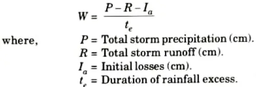
Q28. Describe the W-index.
Ans. In an attempt to refine the 𝞍-index, the initial losses are separated from the total abstractions and an average value of infiltration rate, called W-index, is expressed as
Q29. What is infiltration ? State factors affecting it.
Ans. Infiltration: It is the flow of water into the ground through the soil surface.
Factors affecting infiltration are:
- i. Condition of entry surface.
- ii. Permeability characteristics of soil formation.
- iii Temperature.
- iv. Intensity and duration of rainfall.
Q30. Define duty, delta and base period.
Ans. Duty: Duty denotes a unit of water’s irrigating capability. It is the relationship between the irrigated area of a crop and the amount of irrigation water required for the full growing season of that crop.
Delta: Delta is the total depth of water required by a crop during the entire period the crop is in the field and is denoted by the symbol 𝜟.
Base period: A crop’s base period is the entire period of cultivation from the time irrigation water is first given to prepare the land for planting the crop to the last watering before harvesting.
Q31. What is the purpose of water budget equation in hydrology ?
Ans. The flow of water into and out of a system can be described using a water balance equation.
Q32. Write short note on Global Water Budget.
Ans.
- i. The total quantity of water in the world is estimated to be about 1386 million cubic kilometres (M km3).
- ii. About 96.5 % of this water is contained in the oceans as saline water
- iii. Some of the water on the land amounting to about 1 % of the total water is also saline.
- iv. Thus, only about 35.0 M km3 of fresh water is available.
- v. Out of this about 10.6 M km3 is both liquid and fresh and the remaining 24.4 M km3 is contained in frozen state as ice in the polar region and on mountain tops and glaciers.
Unit-II: Runoff and Hydrographs (Short Question)
Q1. Classify the runoff on the basis of the time delay between the precipitation and the runoff.
Ans. Based on the time delay between the precipitation and the runoff, the runoffs classified into two categories as:
i. Direct runoff. ii. Base flow
Q2. Describe direct runoff.
Ans. Direct runoff is the portion of runoff that enters the stream directly following rainfall. Surface runoff, quick interflow, and rainfall on the stream’s surface are all included. When snow melts, the resulting flow into the stream is likewise a direct runoff.
Q3. Define runoff coefficients.
Ans. Runoff Coefficients: Runoff coefficient is defined as the ratio of runoff (R) and rainfall (P).

Q4. Define base flow.
Ans. Base flow is the delayed flow that reaches a stream essentially as ground water flow. This category frequently includes delayed inter flow.
Q5. What are the flow characteristics of a stream?
Ans. Following are the flow characteristics of a stream:
- i. Rainfall characteristics such as magnitude, intensity, time and spatial distribution, and variability.
- ii. Soil, land use cover, slope, geology, form, and drainage density are examples of catchment features.
- iii. Climate factors influencing evapotranspiration.
Q6. Enumerate different methods of computing the runoff from a catchment.
Ans. Following are the methods for computing the runoff:
i. By linear or exponential regression.
ii. By empirical equations and tables. iii. By infiltration method.
iv. Unit hydrograph. v. By rational method.
Q7. Define a hydrograph.
Ans. A hydrograph is a plot of a stream’s discharge against time in chronological order.
Q8. What is a drought ?
Ans. Drought is a climatic phenomenon characterized by a lack of precipitation supply. This could be caused by below-average rainfall across wide areas, resulting in below-average natural water availability over long periods of time. Drought is a natural calamity and a hydrological extreme similar to flooding.
Q9. Give the types of drought.
Ans. Following are the types of drought:
i. Meteorological drought. ii. Hydrological drought.
iii. Agricultural drought.
Q10. What do you mean by the term flood ? Mention two factors affecting flood.
Ans. A flood is an abnormally high stage in a river, typically the level at which the river overflows its banks and floods the Ans region. Flood damage in terms of loss of life, property, and economic loss due to disruption of economic activity is widely documented. Following are the two factors affecting flood:
- i. Physiographic factors
- ii. Climatic factors.
Q11. Explain factor affecting runoff hydrograph.
Ans. Following are the factors affecting runoff hydrograph:
i. Basin Characteristics:
a. Shape. b. Size. c. Slope
d. Nature of the valley. e. Elevation. f. Drainage density.
ii. Infiltration Characteristics:
a. Land use and cover.
b. Soil type and geological conditions.
c. Lake, swamps and other storage.
iii. Channel Characteristics: Cross section, roughness, and storage capacity.
Q12. Illustrate the climatic factors affecting flood hydrograph.
Ans. Following are the factors affecting flood hydrograph:
- i. Storm Characteristics: Precipitation, intensity, duration, magnitude, and movement of storm.
- ii. Initial loss.
- iii. Evapotranspiration.
Q13. Enumerate the essential components of a hydrograph.
Ans. Following are the essential components of a hydrograph :
- i. The rising limb.
- ii. The crest segment.
- iii. The recession limb.
Q14. What is a unit hydrograph?
Ans. A unit hydrograph is defined as the hydrograph of direct runoff caused by one unit depth (1 cm) of extra rainfall happening uniformly over the basin and at a uniform rate for a specific duration (D hours). The term unit here refers to a unit depth of surplus rainfall, which is typically taken to be 1 cm.
Q15. Enumerate the factors affecting the runoff.
Ans. Following are the various factors affecting the runoff:
- i. Precipitation characteristics.
- ii. Shape and size of the catchment.
- iii. Topography.
- iv. Geological characteristics.
Q16. Write down the assumptions which constitute the foundation for the unit hydrograph theory.
Ans. Following are two basic assumptions constitute the foundation for the unit hydrograph theory:
- i. The time invariance.
- ii. The linear response
Q17. Write down the limitations of unit hydrographs.
Ans. Following are the limitations of unit hydrographs:
- i. Precipitation must only come from rain.
- ii. The catchment should not have abnormally big storage in the form of tanks, ponds, large flood bank storage, and so on, which would interfere with the linear relationship between storage and discharge.
- iii. If the precipitation is non-uniform, the unit hydrograph will not produce good results.
Q18. Give the methods of derivation of unit hydrograph of different duration.
Ans. Following are two methods of derivation of unit hydrograph of different duration:
- i. Method of superposition.
- ii. The S-curve.
Q19. Define synthetic unit hydrograph.
Ans. In the case of ungauged rivers, there is no documented data. In some other circumstances, the available data may be limited. Unit hydrographs are derived for such catchments by linking the relevant basin features to the unit hydrograph shape. The resulting hydrograph is characterized as a synthetic unit hydrograph since it is produced from basin characteristic relationships.
Unit-III: Flood Analysis (Short Question)
Q1. What are the factors on which the runoff coefficient depends?
Ans. Following are the factors which affect the runoff coefficient:
- i. Antecedent moisture conditions.
- ii. Ground slope.
- iii. Overland cover.
- iv Depression storage
- v. Soil moisture.
Q2. Write down the limitations of rational formula.
Ans. Following are the limitations of rational formula:
- i. The formula produces good results only for small catchments (up to 50 km2).
- ii. It is only applicable if the duration of rainfall equals or exceeds the time of concentration (tc).
- iii. Rainfall intensity (i) should be constant across the entire catchment during the concentration period.
- iv. It assumes a constant C value for a given area and all storms, which is not plausible, and so on.
Q3. What are the various empirical formulae for estimating the flood discharge ?
OR
Write down Inglis formula.
Ans. Following are the empirical formulae for estimating the flood discharge:
i. Dicken’s Formula: q = CA3/4
ii. Ryve’s Formula: q = CA2/3
iii. Inglis Formula: Inglis formula is applicable for catchment of former Bombay presidency.
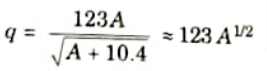
iv. Fanning’s Formula: For American catchments, q = CA5/6
Q4. What do you understand by flood frequency?
Ans. The possibility of a flood being equaled or exceeded is denoted by flood frequency. A 10% frequency means that the flood has a 10% chance of being equaled or exceeded in 100 years.
Q5. Define recurrence interval of flood.
Ans. It denotes the number of years in which a flood is likely to occur once. It is the time between reaching or exceeding a specified flood level. This is commonly represented by the letter T.
Q6. What is a “Return period” ?
Ans. It is the average recurrence interval for a certain event or flood.
Q7. Discuss the probability of occurrence (P).
Ans. i. The likelihood of an event being equaled or exceeded in any given year is the likelihood of its occurrence.
ii. The probability (P) of occurrence of a flood having a recurrence interval of T years in any year or the probability of exceedance is,
P = 1/T
Q8. Enlist the methods of computing the flood peak data.
Ans. Following are two methods of computing the flood peak data :
- i. Annual duration series.
- ii. Partial duration series.
Q9. What is annual flood series ?
Ans. It is made up of the annual maximum flood values from a certain catchment region over a long period of time.
Q10. Describe spillway design flood.
Ans. A design flood is a flood that is used to design the spillway of a storage structure. This word is typically used to define the maximum discharge that can be transmitted through a hydraulic structure without causing damage or posing a major threat to the structure’s integrity.
Q11. Explain standard project flood (SPF).
Ans. This is the flood that would occur if a severe combination of climatic and hydrological conditions were to occur in the region. Very unusual factor combinations are ruled out.
Q12. What do you mean by probable maximum flood (PMF) ?
Ans. The extreme flood that is physically conceivable in a region as a result of severe weather conditions, including uncommon meteorological and hydrological elements.
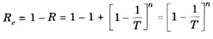
Q13. Describe the reliability.
Ans. The reliability, Re is defined as,
Q14. Write short notes about flood routing
Ans. Flood routing is a method of estimating the flood hydrograph for a stretch of a river by using flood flow data from one or more upstream sections. Routing is invariably included in hydrologic analyses of problems such as flood predictions, flood prevention, reservoir design, and spillway design.
Q15. Enumerate the broad categories of routing.
Ans. Following are two broad categories of routing can be recognized:
i. Reservoir routing. ii. Channel routing.
Q16. What do you understand by flood control ?
Ans. The word flood control is widely used to refer to all of the steps used to reduce flood damage to life and property.
Q17. Classify the flood control measures.
Ans. Following are the classification of flood control measures:
- i. Structural Measures:
- a. Storage and detention reservoirs.
- b. Flood ways.
- c. Watershed management.
- d. Levees (flood embankments).
- e. Channel improvement.
- ii. Non-structural measures:
- a. Flood plain zoning.
- b. Evacuation and relocation.
- c. Flood forecast/warning.
- d. Flood insurance.
Q18. What do you mean by flood forecasting and warning ?
Ans. Flood forecasting far enough in advance allows for a warning to be issued to those who are likely to be affected, as well as for civic authorities to take proper preventative measures. As a result, it serves as a significant and relatively cost non-structural flood management strategy.
Q19. Write down the various flood forecasting techniques.
Ans. Following are the flood forecasting techniques:
- i. Short range forecasts.
- ii. Medium range forecasts.
- iii. Long range forecasts.
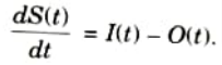
Q20. What do you mean by hydrologic reservoir routing?
Ans. Flow routing is a process for determining the time and quantity of flow at a site on a water route based on the hydrograph at one or more upstream stations. Hydrologic reservoir routing refers to routing using a lumped system technique. It is given by,
Q21. Discuss flood frequency analysis.
Ans. i. Flood frequency analysis is a hydrological approach for predicting flow values matching to specified return periods or probabilities along a river.
ii. Frequency analysis is most typically used to analyze peak instantaneous discharges, but it can also be used to analyze daily mean flow or a volume over a specific time period.
Unit-IV: Groundwater (Short Question)
Q1. What do you understand by groundwater ?
Ans. It is the subsurface water found within the saturated zone of the earth’s crust, where all pores are filled with water.
Q2. Write down the features of groundwater.
Ans. Following are the features of groundwater:
- i. Groundwater is a vast water resource, but it is finite and unevenly distributed.
- ii. Because groundwater and surface water resources are interconnected, they should be considered simultaneously.
Q3. Enumerate the different zones of sub-surface water.
Ans. Water in the soil is called sub surface water and is considered in two zones:
i. Saturated zone. ii. Aeration zone.
Q4. Describe the saturated zone.
Ans. The saturated zone, also known as the groundwater zone, is the area of the soil where all of the pores are filled with water.
Q5. Differentiate between aquitard and aquifuge.
Ans.
| S. No. | Aquitard | Aquifuge |
| 1. | It is a formation that allows only seepage, hence the yield is small when compared to an aquifer. | It is a non-porous and non-permeable geological formation. |
| 2. | A sandy clay unit is an example of aquitard. | Massive compact rock without any fractures is an aquifuge. |
Q6. List the different types of aquifers.
Ans. Following are the types of aquifers:
- i. Unconfined or non-artesian aquifers.
- ii. Confined or artesian aquifers.
Q7. Define an aquifer.
Ans. An aquifer is a saturated formation of earth material that not only holds but also provides enough water.
Q8. Describe the aquiclude.
Ans. Aquiclude is a geological structure that is essentially impervious to water movement. Due to its high porosity, it may be deemed closed to water movement even though it may hold huge amounts of water.
Q9. What do you mean by rain water harvesting ?
Ans. Rainwater harvesting is the practise of collecting rainwater where it falls. It is an excellent strategy for conserving water and increasing water availability for drinking, industrial, or groundwater recharge.
Q10. State the Darcy’s law and its limitations.
Ans. Darey’s law: As per Darey’s law for laminar flow in saturated soils velocity of flow is directly proportional to hydraulic gradient. It can be expressed as :
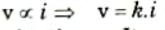
Limitations: It valid for laminar flow (Re < 1).
Q11. Give the advantages of rain water harvesting.
Ans. Following are the advantages of rain water harvesting:
- i. The cost of replenishing subsurface reservoirs is lower than that of surface reservoirs.
- ii. The aquifer also functions as a distribution system.
- iii. It decreases flood risks.
- iv. It improves aquifer production.
- v. Helps to reduce soil erosion.
Q12. What is rooftop water harvesting ?
Ans. The productive utilization of rainwater falling on rooftops of structures is known as rooftop water harvesting.
Q13. Discuss the needs of rainwater harvesting?
Ans. Following are the needs of rainwater harvesting:
- i. To reduce soil erosion.
- ii. To conserve surface water runoff during monsoon.
- iii. To beneficiate water quality in aquifers, etc.
Q14. Describe the soil water zone.
Ans. The soil water zone is located near the ground surface in the principal root band of the vegetation and transports water to the atmosphere via evapotranspiration.
Q15. Explain specific capacity in tube well.
Ans. The discharge per unit drawdown at the well (Q/sw) is known as specific capacity ot a well and is a measure of the performance of the well.
Q16. What is the status and occurrence of ground water in India ?
Ans. Groundwater resources are divided into two categories: static and dynamic. Aquifer characteristics vary from deep alluvial in northern India to hard-rock in much of western, central, and southern India. The static reserves are expected to be 10,812 bcm. The dynamic component is expected to be 432 bcm.
Q17. Write the types of tube well.
Ans. Wells may be classified into two types:
i. Open wells. ii. Tubewells.
The tube well may be of three types:
i Strainer well. ii. Cavity well. iii. Slotted well.
Q18. What is the use of open wells ?
Ans. In rural communities and small farming enterprises, open wells (also known as dug wells) are widely utilized for drinking water supply. They work best in shallow, low-yielding aquifers.
Q19. What are the merits and demerits of partial penetration of wells?
Ans. Merit: In the case of incomplete well penetration, the drawdown near the system can be much lower, which may lessen the danger of settlement damage to neighboring structures or facilities.
Demerit: Since the wells are only partially penetrating, the number of wells necessary to get the desired outcome usually increases. As a result, the cost of this process will be significant.
Q20. Describe well losses.
Ans. When water is pumped out of a well, the total drawdown induced comprises not only the logarithmic drawdown curve at the well face, but also flow through the well screen and axial movement within the well. The latter is referred to as well loss.
Q21. What is transmissibility ?
Ans. It is defined as the rate of flow of water (m/day) through a unit-width vertical aquifer strip extending to full saturation height under a unit hydraulic gradient.
Q22. Explain the terms specific yield and specific retention of an aquifer.
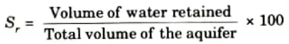
Ans. Specific Retention: The volume of water retained by molecular and surface tension forces, against the force of gravity, expressed as a percentage of the total volume of the saturated aquifer is called specific retention (Sr).
Specific Yield: The specific yield is the actual volume of water that can be recovered by gravity from a unit volume of aquifer material.
Q23. Write down the assumptions of steady flow condition for the confined and unconfined aquifers.
Ans. Following are the assumptions of steady flow in aquifers:
- i. The aquifer is homogeneous, isotropic, and of infinite and real extent, therefore its transmissibility or permeability coefficient is constant everywhere.
- ii. The well has been drilled to the aquifer’s full depth and receives water from the entire thickness of the aquifer.
- iii. Flowlines are radial and horizontal, with laminar flow.
Q24. What is the surface of seepage and free surface curve ?
Ans. Surface of Seepage: The “surface of seepage” is the vertical surface of the well hole that is exposed between the ground, the water forming surface in the well, and the free surface.
Free Surface Curve: The free surface curve is the curve of the surface of groundwater where the pressure is atmospheric.
Q25. State the water well.
Ans. A water well is a vertical hole drilled through the earth strata to lift groundwater to the surface.
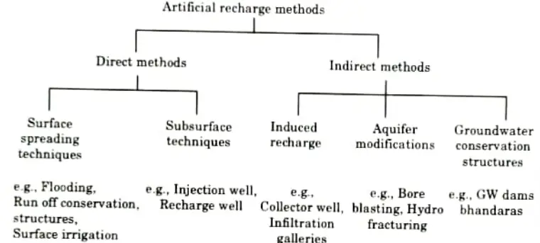
Q26. What are methods to assess the recharge of groundwater in an area ?
Ans.
Unit-V: Groundwater Quality and Modals (Short Question)
Q1. Define the term well completion.
Ans. After constructing a well, adequate sanitary completion is required to generate water that meets public health standards. The process is also called as completion.
Q2. What do you mean by well disinfection ?
Ans. Bacteria may be introduced into a well during drilling procedures. Following development and well testing, a disinfectant, such as chlorine gas or sodium hypochlorite, should be applied to sterilize the well and prevent future biofouling.
Q3. Write down the characteristics of irrigation water quality.
Ans. Following are the characteristics of irrigation water quality:
- i. Total Dissolved Solids (TDS).
- ii. Relative proportion of sodium to other cations.
- iii. Concentration of certain specific elements.
- iv. Residual carbonates.
Q4. Enlist the ground water investigations techniques.
Ans. Following are the ground water investigation techniques:
i. Hydrometeorological study. ii. Hydrogeological study.
iii. Geophysical survey. iv. Tracer techniques.
v. Aerial photographic survey. vi Geochemical and geothermal surveys.
Q5. What are the objectives of hydrogeological investigations ?
Ans. Following are the objectives of hydrogeological investigations:
- i. Define recharge and discharge areas.
- ii. Define major water bearing units.
- iii. Define location, extent and inter-relationship of aquifers.
- iv. Establish physical parameters of aquifers like transmissibility storage coefficient and specific yield.
- v. Estimate total sub-surface storage capacity.
Q6. Explain the artificial recharge.
Ans. Artificial recharge is the technique of intentionally increasing the amount of water recharging the aquifer at a specific region.
Q7. What are the sources of contamination of groundwater ?
Ans. Following are the sources of contamination of groundwater:
- i. Municipal: Sewer leakage, liquid waste, solid waste, and landfill.
- ii. Industrial: Liquid waste, leakage, mining activity, and oil field brine.
- iii. Agricultural: Return flows, fertilizers and pesticides, and animal waste.
- iv. Miscellaneous: Salt water intrusion, acid rain, and deicing salts.
Q8. What are the mechanisms involved in the reduction of pollutants in groundwater ?
Ans. Following are the mechanisms involved in the reduction of pollutants in groundwater:
i. Chemical Treatment Technologies:
a. Chemical precipitation. b. Carbon absorption.
c. lon exchange. d. Chemical oxidation.
e. Surfactant enhanced recovery. f. Permeable reactive barriers
ii. Physical Treatment Technologies:
a. Pump and treat b. Air sparging.
c. Dual phase vacuum extraction. d. Monitoring-well oil skimming.
Q9. List the techniques adopted for groundwater modeling.
Ans. Following are the types of groundwater models:
- i. Physical models.
- ii. Analog models.
- iii. Model based analytical formula coupled with experience
- iv. Numerical models.
Q10. What is upcoming effect in sea water intrusion ?
Ans. When an aquifer has an underlying layer of saline water or sea water and is pumped by a well that only penetrates the top fresh water component of the aquifer, a local rise of the interface occurs; this phenomena is known as the upcoming effect in sea water intrusion.
Q11. Write the principle behind the transport of groundwater contamination in aquifer.
Ans. Advection, dispersion, adsorption and ion exchange, decay, chemical reaction, and biological process are all involved in the transport of pollutants in groundwater.

Engineering Hydrology Btech Quantum PDF, Syllabus, Important Questions
| Label | Link |
|---|---|
| Subject Syllabus | Syllabus |
| Short Questions | Short-question |
| Question paper – 2021-22 | 2021-22 |
Engineering Hydrology Quantum PDF | AKTU Quantum PDF:
| Quantum Series | Links |
| Quantum -2022-23 | 2022-23 |
AKTU Important Links | Btech Syllabus
| Link Name | Links |
|---|---|
| Btech AKTU Circulars | Links |
| Btech AKTU Syllabus | Links |
| Btech AKTU Student Dashboard | Student Dashboard |
| AKTU RESULT (One View) | Student Result |