
Aktu Btech Quantum Notes can help you better prepare for Engineering Hydrology. To excel in your tests, you must have access to critical, recurrent questions and substantial content. Increase your level of understanding right now! Unit-3 Flood Analysis
Dudes 🤔.. You want more useful details regarding this subject. Please keep in mind this as well.

Important Questions For Engineering Hydrology:
*Quantum                *B.tech-Syllabus
*Circulars                 *B.tech AKTU RESULT
* Btech 3rd Year      * Aktu Solved Question Paper
Q1. Explain the rational methods of computing the peak discharge of a small catchment. Where this method is commonly used and what are its merits and demerits ? Also discuss the runoff co-efficient C of the rational formula.
Ans. A. Rational Methods:
- 1. The rational formula is the most rational way of determining peak discharge for small catchments among the numerous forms of empirical relations.
- 2. The greatest flood flow is supposed to be created by a given rainfall intensity that lasts for a time equal to or greater than the period of concentration time in this method (tc).
- 3. The greatest rate of flow from the watershed appears at the basin outlet when the entire region contributes.
- 4. When the rainfall duration approaches the moment of concentration, the runoff progressively increases from zero to peak (tc). If the rainfall continues past midnight, the runoff will be continuous and at its maximum.
- 5. The peak value of runoff is given by,
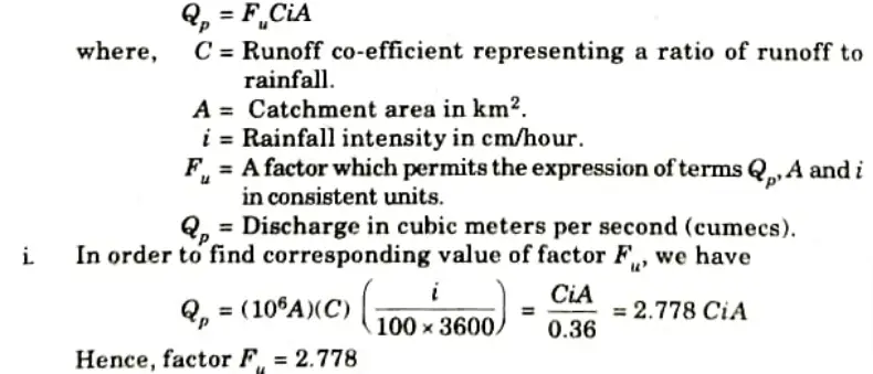
ii. If, however, i is expressed in mm/hour, we have

B. Runoff Co-efficient, C:
- 1. It is a highly critical element that serves the purpose of converting the average rainfall rate of a particular recurrence interval to the peak runoff intensity of the same frequency. Its magnitude depends upon the following factors:
- i. Antecedent moisture conditions.
- ii. Ground slope.
- iii. Ground cover.
- iv. Depression storage.
- v. Soil moisture.
- vi. Shape of drainage area.
- vii. Overland flow velocity.
- viii. Intensity of rainfall.
- ix. Geology of catchment, etc.
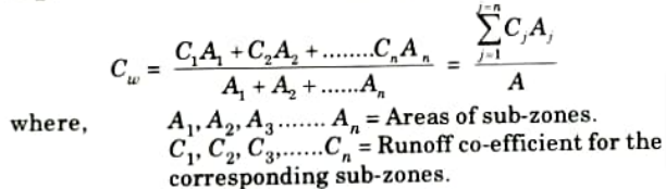
- 2. If a watershed of total area A is non-homogeneous, having component sub-areas having different values of C, a weighted runoff co-efficient (Cw) is computed from the following equation:
C. Merit and Demerits of Rational Methods:
Merits:
- i. The rational technique is the most straightforward way for determining peak discharge.
- ii. It allows for a fast mass balance, i.e. a comparison of rainfall and runoff.
Demerits:
- i. The Rational Method merely delivers the peak discharge and does not provide a hydrograph.
- ii. The accuracy of the rational method is highly dependent on the selection of the runoff coefficient and the delineation of the catchment area.
D. Uses of Rational Method: Rational formula is generally used too estimate the peak flood (Qp) in the design of urban drainage system, storm sewers, design of small culverts, and bridges etc.
Q2. Write short on the following:
1. Flood frequency.
2. Recurrence interval.
3. Return period.
4. Probability of occurrence (P).
Ans. 1. Flood Frequency: The possibility of a flood being equaled or exceeded is denoted by flood frequency. A 10% frequency means that the flood has a 10% chance of being equaled or exceeded in 100 years.
2. Recurrence Interval: The number of years between floods is denoted by the recurrence interval. It is the time between reaching or exceeding a certain flood level. This is commonly represented by the letter T.
3 Return Period: It is the average recurrence interval for a certain event or flood.
4. Probability of Occurrence (P): The probability of an event being equaled or exceeded in any one year is the probability of its occurrence The probability (P) of occurrence of a flood having a recurrence interval of T years in any year or the probability of exceedance is
P = 1 / T
The probability that it will not occur in a year, is known as probability of non-exceedance (q) and is given by,
q = 1 – P
Q3. Explain the following with the help of simple sketches:
1. Partial duration series.
2. Extreme values series.
Ans. 1. Partial Duration Series:
- i. Only one maximum value of flood per year is chosen in the annual hydrologic data series of floods.
- ii. It is possible that some catchments may see more than one independent flood per year, with many of them being of significant magnitude.
- iii. To include all of the large flood peaks in the analysis, flood magnitudes greater than an arbitrary chosen base value are included. This type of data series is known as a partial duration series.
- iv. It is vital to establish that all events considered are independent when utilizing the partial duration series.
- v. Hence, the partial duration series is adopted mostly for rainfall analysis where the conditions of independence of events are easy to establish.
- vi. Its use in flood studies is rather rare.
- vii. The recurrence interval of an event obtained by annual series (TA) and by the partial duration series (Tp) are related by,
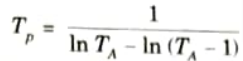
From this, it can be seen that the difference between TA and Tp is significant for TA < 10 years and that for TA > 20, the difference is negligibly small.
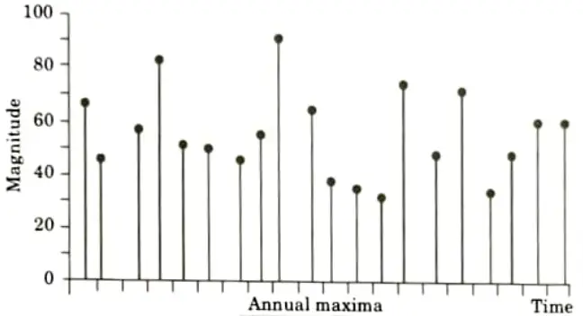
2. Extreme Values Series: It includes largest or smallest values in equal intervals:
- i. Annual series: interval = 1 year.
- ii. Annual maximum series: largest values.
- iii. Annual minimum series: smallest values.
Q4. Describe the term design storm. How is it determined ?
Ans. Design Storm:
- 1. The design storm is required to estimate the design flood for a project using a unit hydrograph.
- 2. This can be the storm’s probable maximum precipitation (PMP) for calculating PMF or a standard project storm (SPS) for calculating SPP.
- 3. Experienced hydro meteorologists use meteorological data to perform the computations. Depending on the availability of trustworthy relevant data and skill, several methods ranging from extremely advanced hydrometeorological methods to simple analysis of past rainfall data are used.
- 4. The following is a brief outline of a procedure followed in India :
- i. First, the crucial rainfall duration is determined. If the flood peak is of interest, this is the basin lag. If the flood volume is of primary importance. The location of the longest storm in the basin is determined.
- ii. Previous big storms in the region that could have occurred in the basin under consideration are chosen. DAD analysis is carried out, and the enclosing curve reflecting the maximum depth-duration relationship for the research basin is obtained.
- iii. Rainfall depths are scaled from the enclosing curve for suitable time intervals (e.g., 6 h). When these increments are applied to the applicable unit hydrograph of the basin, they form a critical sequence that creates the highest flood peak.
- iv. The critical sequence of rainfall increments can be obtained by trial and error. Alternatively. increments of precipitation are first arranged in a table of relevant unit hydrograph ordinates, such that :
- a. The maximum rainfall increment is against the maximum unit hydrograph ordinate.
- b. The second highest rainfall increment is against the second largest unit hydrograph ordinate, and so on.
- c. The sequence of rainfall increments arranged above is now reversed. with the last item first and first item last. The new sequence gives the design storm.
- v. The design storm is then combined with hydrologic abstractions most conductive to high run of, viz., low initial loss and lowest infiltration rate to get the hyetograph of rainfall excess to operate upon the unit hydrograph.
Q5. Define flood routing. Discuss broad categories of routing.
Ans. Flood Routing:
It is the method of determining the flood hydrograph at a stretch of a river by using flood flow data from one or more upstream sections.
In these applications two broad categories of routing can be recognized. These are:
1. Reservoir Routing:
- i. Reservoir routing investigates the effect of a flood wave entering a reservoir.
- ii. Using the reservoir’s volume-elevation characteristic and the outflow-elevation connection for the reservoir’s spillways and other outlet structures, the influence of a flood wave entering the reservoir is examined to anticipate the variations in reservoir elevation and outflow discharge with time.
- iii. This form of reservoir routing is essential:
- a. In the capacity design of spillways and other reservoir outlet structures.
- b. In the location and sizing of reservoir capacity to fulfill specific requirements.
2. Channel Routing:
- i. Channel routing investigates the change in shape of a hydrograph as it flows along a channel.
- ii. This type of routing seeks to forecast the flood hydrograph at various sections of the reach by taking into account the channel reach and an input hydrograph at the upstream end.
- iii. Knowledge on flood-peak attenuation and the length of highwater levels gained from channel routing is critical in flood-forecasting and flood-protection activities.
- iv. A variety of routing methods are available and they can be broadly classified into two categories as :
- a. Hydrologic routing methods rely heavily on the continuity equation.
- b. Hydraulic methods, on the other hand, use the continuity equation in conjunction with the unsteady flow equation of motion.
Q6. What do you mean by flood control ? Explain any two methods of flood control and also mention any two empirical formulate for estimating flood?
Ans. A. Flood Control: The word flood control is widely used to refer to all of the steps used to reduce flood damage to life and property.
Structural Methods: Following are the structural method:
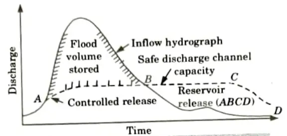
1. Storage Reservoir:
- i. Storage reservoirs are one of the most dependable and successful flood control solutions.
- ii. Ideally, in this strategy, a portion of the reservoir’s storage is maintained aside to absorb the incoming flood.
- iii. Furthermore, the stored water is released gradually over time so that downstream canals are not swamped.
- iv. Figure depicts an optimal flood control reservoir operating plan.
- v. A significant number of reservoirs at strategic places in the catchment will be required to ensure complete flood control along the whole length of the river.
- vi. The Hirakud and Damodar Valley Corporate (DVC) reservoirs are two significant reservoirs in the country with specified volumes designated for flood absorption.
2 Levees:
- i. Levees, also known as dikes or flood embankments, are earthen walls built parallel to the flow of a river to limit its cross-sectional breadth and confine it to a defined channel.
- ii. Flood walls are masonry constructions that are used to confine the river in a similar fashion to levees. They are used to protect vital structures against flooding, especially in areas where land is scarce.
- iii. Levee heights shall be higher than the design flood level to allow for adequate free board.
- iv. The limitation of the river to a fixed route prevents inundation and subsequent damage to huge swaths of land.
- v. Levees are one of the world’s oldest and most widely used systems of flood protection. Also, they are most likely the least expensive structural flood-control techniques.
- vi. While the protection provided by a levee against flood damage is clear, the potential devastation in the event of levee failure is generally overlooked.
- vii. The design of a levee is a substantial effort that must take into account expenses and economic benefits.
- viii. For complete safety against all types of saturation and drawdown possibilities, the cross-section of a levee must be constructed like an earth dam.
3. Floodways:
- i. Floodways are natural pathways through which a portion of the water is channeled during high stages.
- ii. A floodway can be either natural or man-made, and its position is mostly determined by geography.
- iii. In general, if practicable, floodways are a cost-effective alternative to other structural flood-control techniques.
- iv. To reduce the level of the river Jhelum at Srinagar, a supplementary channel has been constructed to act as a floodway with a capacity of 300 m3/s. This channel is located 5 km upstream of Srinagar city and has its outfall in Lake Wullar.
- v. In Andhra Pradesh, a floodway has been constructed to transfer a part of the flood waters of the river Budamaru to river Krishna to prevent flood damages to the urban areas lying on the downstream reaches of the river Budamaru.
4. Channel Improvement: The works under this category involve:
- i. Channel widening or deepening to increase cross-sectional area.
- ii. Reducing channel roughness by removing vegetation from the channel’s perimeter.
- iii. Cutoff channels short circuit meander loops, resulting in greater slopes.
5. Watershed Management:
- i. Watershed management and land treatment in the catchment try to reduce and delay runoff before it enters the river.
- ii. Watershed management strategies include increasing vegetative and soil cover in conjunction with land treatment techniques such as Nala Bunds, check dams, contour bunding, zing terraces, and so on.
- iii. These measures aim to improve the soil’s water infiltration capability and reduce soil erosion.
- iv. Watershed treatment is becoming an essential component of flood management.
- v. While watershed management methods are thought to lessen minor and medium floods, the magnitude of major floods is unlikely to be influenced.
Empirical Formulae: Some of the empirical formulae for estimating the flood discharge are given below. Most of these are in the form:
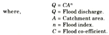
Both C and n depend upon various factors, such as :
- i. Size, shape and location of catchment.
- ii. Topography of the catchment.
- iii. Intensity and duration of rainfall, and distribution pattern of the storm over the basin.

Engineering Hydrology Btech Quantum PDF, Syllabus, Important Questions
| Label | Link |
|---|---|
| Subject Syllabus | Syllabus |
| Short Questions | Short-question |
| Question paper – 2021-22 | 2021-22 |
Engineering Hydrology Quantum PDF | AKTU Quantum PDF:
| Quantum Series | Links |
| Quantum -2022-23 | 2022-23 |
AKTU Important Links | Btech Syllabus
| Link Name | Links |
|---|---|
| Btech AKTU Circulars | Links |
| Btech AKTU Syllabus | Links |
| Btech AKTU Student Dashboard | Student Dashboard |
| AKTU RESULT (One View) | Student Result |